

A pre-Thanksgiving snowstorm has already traversed the Central Plains toward the upper Midwest. The storm is producing dangerous weather conditions during one of the busiest driving days of the year, reported NBC News.
Winter Storm Dorothy dumped 7 to 12 inches of snow late Monday into Tuesday across Denver.
Winter storm warnings and winter weather advisories have already been posted for many regions in the Central Plains and upper Midwest on Wednesday.
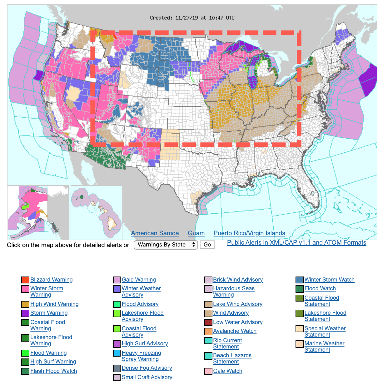
Heavy snow and winds are expected for parts of the upper Mississippi Valley into the northern Great Lakes Wednesday. Blizzard-like conditions could make driving unsafe ahead of holiday travels.
Here's a look at where Winter Storm #Dorothy will be tracking today. @FeliciaCombsTWC & I will detail how much snow will add up. Oh and BTW…there's another storm (#Ezekiel) behind it. We've got the forecast…9am-1pm ET on the @weatherchannel. pic.twitter.com/ds1Fxbgvjy
— Alex Wallace (@TWCAlexWallace) November 26, 2019
Dorothy is expected to dump nearly a foot of snow across central Nebraska to western and northern Iowa, southeastern South Dakota, southeast Minnesota, northern Wisconsin and the Upper Peninsula of Michigan by late evening.
“It’s going to be bad,” said Todd Krause, a National Weather Service (NWS) meteorologist.
“The snow is going to come down hard. It’s going to come down fast,” Krause said. “Visibility is going to be very, very poor during the height of the snowstorm.”
Strong winds from the winter storm could lead to airport delays, damaged infrastructure, power outages, and snowdrifts across the Midwest and Great Lakes.
“Strong winds will contribute to more blowing and drifting snow in these areas, resulting in dangerous travel conditions,” NWS said.
The storm will then move towards the Northeast on Thursday could produce high winds in New York City, possibly grounding the iconic floats seen at the Macy’s Thanksgiving Day Parade. Temperatures will be in the 50s on Thursday, with winds sustained above 20 mph, could gust up to 35-40 mph.
In the West, a “bomb cyclone” has made landfall in the mountain areas of Oregon and Northern California.
“This low pressure system will likely undergo bombogenesis (pressure drop of at least 24mb in 24 hours) by late Tuesday afternoon,” said NWS, “at which point it will likely become a sub-980 mb low with hurricane force winds over the offshore waters!”
Here's a satellite look at the "bomb cyclone" that will be moving into the area over the next few hours. Hopefully everyone is prepared for strong, significant storm today! #orwx #cawx pic.twitter.com/hJwblDOEgO
— NWS Medford (@NWSMedford) November 26, 2019
Blizzard conditions are expected for elevated regions in southern Oregon and Northern California through Thanksgiving.
Tens of millions of people are expected to travel Wednesday-Thursday for the holiday season. Several parts of the US will experience fierce weather that may make it unsafe to drive.
It is my sincere desire to provide readers of this site with the best unbiased information available, and a forum where it can be discussed openly, as our Founders intended. But it is not easy nor inexpensive to do so, especially when those who wish to prevent us from making the truth known, attack us without mercy on all fronts on a daily basis. So each time you visit the site, I would ask that you consider the value that you receive and have received from The Burning Platform and the community of which you are a vital part. I can't do it all alone, and I need your help and support to keep it alive. Please consider contributing an amount commensurate to the value that you receive from this site and community, or even by becoming a sustaining supporter through periodic contributions. [Burning Platform LLC - PO Box 1520 Kulpsville, PA 19443] or Paypal
-----------------------------------------------------
To donate via Stripe, click here.
-----------------------------------------------------
Use promo code ILMF2, and save up to 66% on all MyPillow purchases. (The Burning Platform benefits when you use this promo code.)


Looks like we got about 6” in Minneapolis. Time to hang up the bike in the garage until March.
Lots of wind and blowing snow here in MT, nothing unusual. The bike has been hung up since Sept.
Getcha one of these…
Timbersleds are very popular here….we have world-class psychopaths in the outdoors….ice climbing, mountain climbing, ski sailing, parasailing, snow machines, alpine touring and hiking, biking etc…..
So now we have winter storm Dorothy. What next? Thunderstorm Frank? Rain shower Marvin? Sunny day Beth?
Got a foot, maybe 15 inches, in Denver. Sunny today, but still cold. I’m holding out some hope that we will be able to golf by Dec. 7-8, when my BIL is here.
Denver is like that….endless cycles of hot, cold….usually on the same day.
Been here and there. Seen towns that typically get more snow, and towns that usually get very little.
Never seen a town as ineffective at clearing roads as Denver.
Just more proof that global warming is real.
heh…70’s here in Texas, may get down to 50’s and guaranteed no snow…
Just more proof that global cooling is real.
When I was young we had to walk five miles in the snow to get to school.
Today we are soft. Our kids go to school in a bus.