

The weather weanies have been referencing the January 1996 storm that hit my area. We had just moved into our new house in October 1995. I was 32 years old and in good shape. We had one two year old. I still remember that storm. It snowed and snowed and snowed for 48 hours. We ended up with 31 inches of snow, but the wind blew towards my house and the drifts were four feet. I had one shovel. It took me 8 hours to shovel one side of the driveway. I used to like big snowstorms. I don’t anymore. I hope the forecasts are wrong. I’m not up for shoveling for eight hours again.

Submitted by Tyler Durden on 01/19/2016 15:07 -0500
With the exception of a handful of one-time events, it had been such a mild winter across most of the U.S. that numerous retailers have been complaining how negatively impacted their topline has been as a result of the warmer weather (clearly having forgotten how they complained about precisely the opposite in prior years).
All that is about to change, and all those warm weather-slammed retailers are about to get just the top line-boosting gift they have been waiting for because according to AccuWeather, the Northeast – from Charleston all the way to Boston – is about to be hit with a major winter storm, with the potential for heavy snow to impact more than 50 million people at the end of the week.
AccuWeather Senior Meteorologist Dave Dombek says that “we are just now at the point [of the winter] where the air is cold enough with the ongoing storms to awaken a sleeping giant in terms of a snowstorm.”

He adds that unlike most storms so far this winter, this system will have enough cold air to produce snow and disruptions to daily activities in areas of the East that have received little thus far.
The exact track of the storm will hold the key as to which areas in the mid-Atlantic and southern New England are hit with heavy snow, dangerous highway travel and scores of flight delays and cancellations during Friday into Saturday.
The heavy snow with the storm is likely to have a fairly sharp northern edge. At this time, the northern edge of the storm is most likely to extend from southern Ohio to southern New England. A distance of less than 50 miles could bring snowfall ranging from an inch or less to more than a foot.

There is a chance the major storm will not evolve into a full-blown blizzard: if the storm develops to its full potential and takes a track just off the mid-Atlantic and New England coasts, then a blizzard can unfold. The storm could shut down highways and perhaps cause airport closures.
According to AccuWeather Chief Meteorologist Elliot Abrams, “This could be a long-duration snowfall that could last more than 24 hours in some locations.” This is also the type of storm that is likely to produce a very heavy rate of snow.
Based on the most likely storm track at this early stage, areas from the Virginia and West Virginia mountains to the major cities from Washington, D.C., to Baltimore and Philadelphia, as well as the suburbs, are included in the swath of heavy snow potential.
AccuWeather warns residents in the region that since the storm will strengthen rapidly, reduce its forward speed and tap plenty of moisture from the Gulf of Mexico and the Atlantic Ocean on its path, snowfall rates of 1-3 inches per hour are possible. There is the potential for the hardest-hit areas to receive 1-2 feet of snow or more from the storm, where rain does not mix in.
According to AccuWeather Senior Meteorologist Brett Anderson, “Should the storm continue northeastward, rather than turn more to the east at the last minute, New York City, Boston, Providence, Rhode Island, and Hartford, Connecticut, would also be buried in snow.”
A wintry mix is likely to occur from northwestern North Carolina to the Delmarva Peninsula, southern New Jersey and Long Island. Exactly how much snow accumulates in the coastal areas will depend on the amount of rain, if any, that mixes in.
In the swath of the heaviest snow, motorists who venture out during the storm could become stranded.
Thunder and lightning could accompany the heavy snow in some coastal locations. As the storm strengthens near the coast, winds will increase, and blowing and drifting of snow will occur.
But while AccuWeather is still on the fences about the storm’s ultimate impact, the WaPo’s DC-based meteorologists are far less sanguine and are confident that the storm’s impact is now assured: as it reported, “a high-impact snowstorm for the region is nearing inevitability and there is some chance it will be historic, paralyzing travel and disrupting normal routines.”

They add that “every major computer model is now forecasting double-digit snowfall totals for the D.C. area Friday and Saturday.”
If the WaPo is accurate, the storm will be truly ‘historic’: “The agreement among forecast models for a severe winter storm in this case is remarkable and a hallmark of some of our most memorable snow events.” However, even the WaPo hedges somewhat and notes that “this storm is still three days from starting, which means there is time for shifts.”

Meanwhile, the National Weather Service has raised its winter-storm-threat scale to its highest level. It warns there is potential for significant travel delays, closures, and threats to life and property, and is urging residents to start planning ahead.
In addition to heavy snow, the combination of wet snow and high winds are possible Friday night through Saturday, which could lead to power outages.
How much snow should the up to 50 million residents in the impacted region anticipate?
The snow is forecast to begin between Friday morning and afternoon. The heaviest snowfall and most difficult conditions are likely to start late Friday afternoon into Saturday.
Exactly how much snow falls and where is sensitive to the exact storm track, which will invariably jump around a bit. As areas along and east of Interstate 95 will be close to the snow-sleet-rain line, these shifts could well have profound implications on specific amounts and the overall storm impact.
There is still a small chance the storm tracks far enough to the southeast that this is more of a moderate snowstorm rather than a blockbuster. As such, we are not yet in position to forecast specific snow amounts, but rather provide percent likelihoods of different totals.
For the D.C. metro-area, the WaPo gives the following prediction:
- Chance of at least 1 inch: 90 percent
- Chance of at least 4 inches: 75 percent
- Chance of at least 8 inches: 65 percent
- Chance of at least 12 inches: 50 percent
- Chance of at least 20 inches: 15 percent
The answer will be revealed on Friday, and if the worst case scenarios are accurate it will present retailers with a major quandary, because if after blaming Q4 sales on warm weather, should the top line not recur in the first quarter after what could be a “historic” snow storm, then the contradictory explanations will get more problematic.
And then there is the US economy in general: recall that in 2014 and 2015 it was the harsh winter weather that was blamed for the dramatic drop in Q1 GDP of both years. Well, with Q4 GDP already tracking at 0.6% according to the Atlanta Fed, and 0.1% according to JPM – and could potentially be negative – it will be the height of scapegoating irony if GDP declines from a zero, or negative, print and one strong winter storm is the factor that pushes the US into a technical recession.
At least the NBER will have a convenient climatic “alibi” on which to blame the “first recession” in 7 years.


maybe a glacier will instantly form over w. d. c., resulting in the deposition of its’ scrapings out to sea!
Bring it on, snow blower is all gassed up and ran fine last I checked. After last winter nothing will phase me. Admin, don’t you still have a teenager at home. You shouldn’t be doing heavy lifting at your advanced age.
Bob.
Where I am in Winchester, Virginia, the “European” model is predicting as much as 44 inches. We had 40 inches at our home in the blizzard of ’96. It hit on a Friday night in early January and we missed a week and a half of school. Our driveway was a quarter-mile long through the woods and it took a few hours to wade to our front door through the waist-deep snow. Might need to get out of town before the end of the week!
A foot and a half of snow? That’s historic? Good God, the news is kabuki.
I’m pretty sure right after the storm, a big fucking meteor will fly by, and melt all the snow. Don’t worry.
I’m here in Minne-so-cold. It was -10 last night. A really god forsaken place, but it keeps down the neegrows, SPICS. Unfortunately the US of A has imported 50,000 Somali’s.
Year 2000 – another lying scare (fear-mongering claim by the GloBull Warming crowd:
According to Dr David Viner, a senior research scientist at the climatic research unit (CRU) of the University of East Anglia, within a few years winter snowfall will become “a very rare and exciting event”.
“Children just aren’t going to know what snow is,” he said.
Note: CRU is the ‘sister’ in Britain to the IPCC.
Heh
It was, apocalyptic, living on the farm, 50 below windchills for 3 days straight while the snow piled into 8 foot drifts. what a great time it was to be alive.
Admin, buy a sleigh shovel. My driveway is about 50 feet long. A foot of snow will take me about 3 hours to clear with a normal shovel. Bought a monster sleigh shovel this year, and it takes me a third of the time and without all the Advil. The 50 bucks was well worth it.
Send it my way! I wouldn’t mind shoveling snow for eight hours. I’m not as young or as in good a shape as I once was either but I do like shoveling snow! Although for that much snow I’d break out the snowblower and do 4 or 5 driveways.
This looks pretty interesting ….. $160
Here’s a picture …. you never have to bend over!
[img [/img]
Strap on a plow to old people …. seems reasonable to me.
[img [/img]
Here is a comment from page 4 of the comments section @ ZH (where this TBP column originated):
Tue, 01/19/2016 – 16:28 | Post # 7068402 by Jack Burton
The mositure to produce record snowfall is present just off shore of the North East United States. Record warm waters, allow record moisture to be evaporated into the atmosphere and turned to snow by a cold front.
Why is Atlantic water record warm? The current that normally carriers warm Gulf Water north to off of Iceland and Greenland, where heavy with salt, it sinks below the less salty surface water, has slowed down considerably. Ice cold fresh water has built up off of Iceland and Greenland and Labrador, preventing the sinking and normal current flows into the depths. Thus extra warm water builds up off of NE America. That pool of record warm gulf water is the fuel.
This is a recent development. The North Atlantic Conveyor current is slowing as it’s blocking the sinking effects that are key to normal ocean currents and normal climate.
Greenland was setting all records the last few weeks, even melting in mid winter, with several major glaciers opening up and spewing cold fresh water into the seas.
The effect of this Dipol “Hot Water next to Cold Water” is a storm creator. This is what has driven storm after storm onto the UK, with record after record flood.
Nothing at all seems set to change this new normal. In fact, the effect should increase heavily in the next few years.
If you live in the UK, in any flood zone, you have this year to sell, or you never will be able to sell. Past history shows that slowing of the Atlantic Current is linked to UK flood disaster.
=========================================================================
Accepting the above as accurate, it may be assumed that if the wind shifts direction during the storm to NE or NNE off of the coast of New England, this moisture the commenter refers to may increase the snow. . . and help it pile up and drift as JimQ remembers from ’96. Que sera, sera.
[img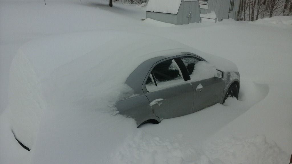 [/img]
This was my backyard last Saturday. Maybe I’ll post an update Sunday. Winter gotta love it…
You all see that first picture?
[img [/img]
Looks like a big blue icy glove reaching for my ass…
That’s okay… ain’t but a thing.
Biggest hassle is going down to the pong and smashing a hole in the ice with a sledgehammer so the animals can get to the water…
I don’t “shovel” anymore… got a plow that hooks to the tractor.
John Angelo says: Where I am in Winchester, Virginia, the “European” model is predicting as much as 44 inches. We had 40 inches at our home in the blizzard of ’96.
——————–
I remember the blizzard of 1966 here in Northern VA. Almost 40 inches then, too, with drifts up to 6 feet. Also we had a big dump in 2003–about 30 inches.
44″ would be historic, however.
[img [/img]
I think there was something like 8 storms this past winter that dumped more than a foot of snow where I live. Epic winter!
[img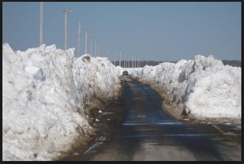 [/img]
Picture from Annapolis Valley.
We did have a storm once. So bad we named it White Juan. Parts of the province got 150cm of snow in one storm. Winter is weird around here. Some years hardly any snow, other you’d think a new ice age had begun. What kills me is that either way there are folks out there who will spin it as yet more proof of global warming.
[img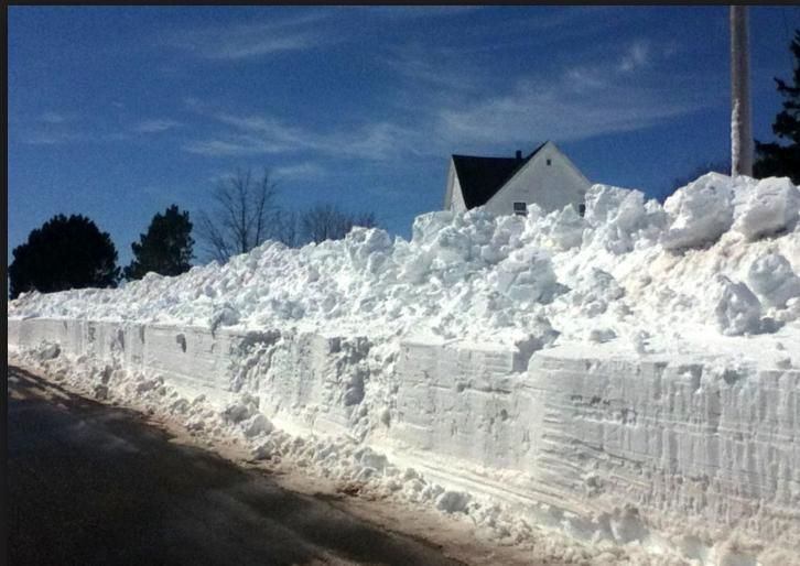 [/img]
This one is from Prince Edward Island. We weren’t quite as bad here. But snow didn’t finally all melt until the middle of May.
A-yup: the area weather forecast for south-east Mass. (near R.I.), says the prevailing winds will be from NNE to NE (New England’s famed “nor’easter”) from Friday night through Saturday night; Saturday daytime wind velocities will be 28 with gusts to 40, and 18 at night, gusting to 31. However, it’ll only total about 7.5″, mostly on Sat, eve.
Maybe it won’t be so bad. Still, Vic DiBitetto better saddle up the grocery reconnaissance vehicle and go get the bread and milk . . .
};^D
Well. It is winter.
Rob in Nova Scotia said “Parts of the province got 150cm of snow in one storm”.
150cm doesn’t register in most of our brains here in the U.S. “59 inches”, or “5 feet” would register better. An impressive amount BTW, even by my Minnesota standards.
It’s interesting to note that the only country that still measures in inches, feet, gallons, miles, Fahrenheit etc. is also the only country to land men on the moon. NASA probably used metric figures to accomplish it though!
Hey Dutchman…..maybe that asteroid will not only melt the snow, but turn it to steam in a flash, thereby causing armageddon on the potomac…………
ummmm……..flash steamed politician
Bring it on! We have the jenny at-the-ready and the tractor has the blade on…For us, the biggest pain is carving the path to the barn and then dealing with frozen ice in the water buckets and water pans. It’s gonna be a lousy time for goats, though….they hate getting their hooves wet.
We’re in the northern Shenandoah Valley. Looks like there are a few TBPers here — we need the tshirt.
The snow storm of 1996 left us 48-inches of snow. The kiddos didn’t have school for a week but they packed snow and we all had fun sledding in the hills. We didn’t get any snowplows out to our area for 5 days. No worries, we were fine.
In 2009, we had another blizzard and on top of all the snow, we lost power for 4 1/2 days. The jenny took care of the freezer and fridge so no food loss. We have a wood stove so we had heat. We cook w/ propane and also have a wood cookstove, so we ate hot foods. It was damn cold but we hunkered down. I’m not in an area where people have much sense: only 1 of our neighbors has a wood stove and even then, only seldom uses it. After the loss of power for 4 days, you’d think some of them would learn a lesson. But no….I wonder how many will be kicking themselves in the rears after this weekend. More than likely, we’ll lose power for a few days and those who are still unprepared will get to do a repeat. Proof that you can’t fix stupid…
Hope everyone in the East stays warm and safe…
[img [/img]
We actually don’t get much snow here in MN. I think the average is about 45″ a year. Problem is when there’s still snow left over from last winter.
I think that is among the most significant info for me.
And i am satisfied studying your article. But should commentary on few general issues, The web
site style is perfect, the articles is really great : D.
Just right job, cheers