


It has begun to rain where I live. This shows how large this storm is. It won’t make landfall at the Jersey shore until Monday night and it is still 400 miles away and it is already raining here. I did my normal 7:00 am Sunday trek to Wal-Mart and Giant for our normal weekly needs. There is usually no one shopping at this time. Today, there were hundreds of people milling about. Situations like this give me a glimpse into the future. The flashlight, battery and bread aisles were bare. I would guess that 98% of Americans don’t have enough supplies to survive for one week before riots start. What will 60 million East Coast morons do when the charge on their iPhones and IPads runs out? How will they tweet? How will they know if their BFF Melissa is sad on Facebook. I think a few people are going to get a slap in the face over the next few days and get a dose of reality about the future.
In the meantime, I will blog on this thread during the course of the storm. I will have power because I bought a generator over a year ago. It feels good not being panicked like the masses. Philadelphia has already declared a state of emergency, so I expect to have a day off tomorrow. If not, I’ll work from home. I wouldn’t want to run into the rats that will be coming out of the sewer drains in West Philly.
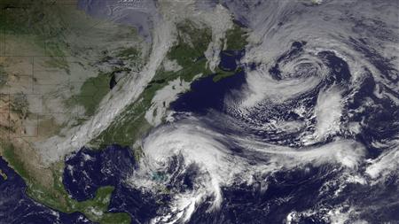
Awaiting Sandy

The effects of Sandy have arrived as the outer bands of rain are affecting parts of the region. There is a band of moderate rain stretching from eastern PA southward to Delaware as of 7:30am. The rain will increase in coverage throughout the day. It will mainly be light to moderate, as the heavier rainfall won’t arrive until later tonight and during the overnight hours.
Winds will be on the increase throughout the day from the Northeast. They will range from 10-15 mph, but there will be occasional gusts over 20 mph. The winds will be stronger at the beaches, gusting over 30 mph. With the rain, the winds will continue to increase as we head into the evening hours.
Hurricane Sandy continues to move Northeast off the east coast. Throughout the day, she will begin to turn north and eventually make that turn west towards the mid-Atlantic coast. Landfall continues to be in NJ late tomorrow night somewhere along the NJ coast between Ocean City and Seaside Heights.
While the weather will be going downhill, there is still time to make final preparations for Hurricane Sandy before the brunt of the storm arrives tomorrow. I can’t stress enough how dangerous of a situation this is and the effects it will have for everyone in the region over the next few days. Make sure you have several days worth of food, water and other essentials in the event you lose power for an extended period. This is going to be a truly unprecedented event and one that many people have never experienced.


Here is an interesting question. It is two weeks before the election.
Will this imminent disaster benefit or hinder Obama’s election chances?
From a PR standpoint he will attempt to take advantage of acting Presidential and comforting the victims. He will throw hundreds of billions in “emergency aid” (aka your tax dollars) at the states in order to win votes.
But, we will get to witness the Federal Government in action for two weeks before the election. We all know they are incompetent, bureaucratic, dysfunctional and fucked up. If the response is as incompetent as I would expect, Obama would lose votes.
What do you think?
Top 12 Largest Atlantic Tropical Cyclones
These sizes were determined using the Extended Best Track dataset (Demuth et. al 2006).
Name, Year: Radius of tropical storm-force winds (nautical miles)
1. Olga, 2001: 600
2. Lili, 1996, 450
2. Sandy, 2012: 450
3. Tanya 1995: 400
3. Irene 1999: 400
3. Igor, 2010: 400
4. Wilma, 2005: 375
5. Felix, 1995: 360
5. Michael, 2000 360
5. Irene, 2005: 360
5. Irene, 2005 360
5. Florence, 2006: 360
Stay safe, Admin. Hoping for the best for everything and everybody at Wildwood and along the Jersey shore too. Godspeed!
[img]http://ts1.mm.bing.net/th?id=I.4934351236695516&pid=1.7&w=222&h=145&c=7&rs=1[/img]
God Bless !
Power may not be restored in many locations in the northeast. The northeast is virtually solid blue. These people must be allowed to vote!! Obama issues an EO to postpone the elections … maybe indefinitely.
Could happen!
Shit, stuck, you may be onto something there. How fucking frightening is that?
Stay safe Jim.
Last November we had an ice storm …. had no power for 6 days … lost a lot of food, had some cold dark nights …. a pretty shitty experience.
So we bought a 5k watt generator.
This summer we tried to sell the house (now off the market). We didn’t want to drag along/move the generator. So I made a big sign and nailed it to the tree in the front yard —- “Brand NEW generator, never used — $500 ($200 below cost)”. Left that sign out for about two weeks. No bites. Not one.
Fast forward to ….. yesterday. THREE people on our street ring our doorbell; “You still want to sell that generator?” lol lol lmfao “No!!”. haha One guy asked how much I paid for it. I told him “$700”. He offers me $900!! I say “No, thanks”. Then he says, “$1,000”!! Seriously. I contempate this for a few seconds. Then I realize that having to re-attach my balls after Ms Freud cuts them off will eat all my profits, so I again say, “I just can’t do it. Sorry.”
Tell ya what. That sucker goes right over admins house i am out of hereand off the internet for good. Think about it folks, they steered a freakin hurricane over his house. This is the motherof all conspiracy theory wetdreams.
President uses HARP to silence blogger, hundreds die and billions in damage.
We have several large plastic storage containers. Going to fill all of them with water. I’m guessing between 200-300 gallons. Got enough food and water to last two weeks, maybe longer. My only serious worry? That the four huge fucking trees in the yard don’t fall on the house. Maybe we should sleep in the extra bedroom in the basement.
YIKES!!!
I PICKED THE WRONG WEEK TO QUIT SNIFFING GLUE
Best of luck to you folks up there!
WOO HOO – My University is closed Monday & Tuesday
I have two days off from school!!!!
Only essential personnel have to report Monday and Tuesday.
Thank God I’m not essential.
This June a ‘derecho’ passed over Washington, D.C. This violent thunderstorm front knocked out electric power in the metro area for days. Figure Sandy to do the same so Obama’s posturing will be invisible and irrelevant in the aftermath of the storm. This is a catastrophe for him as rounding up the underclass and getting them to the polls requires working infrastructure which won’t be working. All the effort put into ‘early’ voting will be for naught unless, as Stucky suggested, Obama can somehow extend the voting in the most affected states but how he can do this in Pennsylvania and New Jersey without the collusion of the governors is not clear.
It will be Wednesday before damage assessments can even begin. Swollen creeks and rivers will have to recede before repairs can be attempted in many areas. As this storm will impact a wide area utility crews will have to be brought in from far away. That too will take 2 or 3 days for them to travel, stage and be assigned work areas. Figure Friday as the earliest non emergency repairs can begin. Figure 10% per day having their power restored beginning Saturday so more than half the people who lost power will still be without on election day.. Landline phones, cable TV and ISP service will also be lost. Not good for the Democrats.
I’d say the political fallout from the storm could go for or against the Pres. Just depends on how bad the damage is and how well (or poorly) the disaster response is.
Good response = good numbers for Obummer.
Utter chaos and long power outages make him look bad and give the Romney camp more ammunition to point out his lack of leadership ability. Of course, they have to be careful if they try that tack. It could backfire. Generally speaking Americans like to pull together in a true disaster.
Glad to hear that those of you most likely to be affected are as ready as you can get. Hunker down and don’t take any necessary chances. It looks very, very bad to me.
Hope that generator gives you a nice clean sine wave for the computer. I’m looking forward to the play-by-play.
“no unnecessary chances”. You know what I meant.
It’s not the wind or the rain that kills you with a hurricane.
It’s the storm surge that kills most people with floods a distant second. You hear about the freak deaths (“Speared by a power pole!” ” Man gets blown off his balcony!”) but the serious shit comes in with the tide.
That’s why I sit 65 miles from either coast her in Central Florida.. I’m at 65 feet elevation (above mean high tide mark over on the coasts) and that’ll take a hell of a storm surge to get here.
Of course if the volcano in the Canary Islands burps and half the mountain slips into the sea, we’ll get a mile high tsunami that wipe out everything between the coast and the Blue Ridge mountains, up the Mississippi River Basin to Michigan.. Florida will be a sand dune again, probably 200 feet down when the waves stop sloshing.
Life is fragile. Mother Nature doesn’t give a shit about you and I – no more so than the politicians and PTB care. Believe it..
MA
All my Yankee “friends” are in my thoughts and prayers. “canes really suck, they are no fun at all. Take some pictures of the 30 blocks and let us see how the FSA did. Regards, ragman.
Muck About you may be spot on but have the wrong ocean. Yesterday’s 7.7 quake off British Columbia could be the prelude to the next big seismic event on the Pacific ring of fire. If you think about what has been happening around the Pacific basin over the past 8 years it is really unusual.
We’ve had three 9.0 plus quakes in less than 8 years. The Boxing Day quake off Sumatra in 2004, the Chilean mega quake on February 27, 2010 and the March 11, 2011 Japanese mega quake. BTW the Japanese mega quake was preceded a month earlier by a 7 plus quake. Dormant has been the Cascadian subduction zone off our Pacific Northwest. It is overdue for a major seismic event.
Geologists tend to not believe a quake in one region has any immediate effect on adjacent regions but our understanding of what goes on 20 miles below our feet is limited. 3 mega quakes in 8 years is really unprecedented and to this laymen suggests something major is going on around the Pacific basin.
I made a big mistake. I went to Wildwood to check it out for myself.
[img [/img]
JUST KIDDING
Admin and Avalon on Wednesday
[img [/img]
Admin & Avalon next Friday
[img [/img]
A glimpse into our future
[img [/img]
Forecast for Monday, October 28, 2012
Hurricane Sandy has actually continued to look slightly better on the visible satellite imagery at early afternoon on this Sunday as a hurricane structure. There appears to be thunderstorm activity wrapping around the center of circulation creating an eye and eye wall feature. While Sandy appeared to be more of a comma shape rather than a donut shape just a day ago, it appears that this hurricane has so far been able to fight off changing the overall structure. However, we still anticipate the transition into a very potent Nor’easter throughout Monday as it will be interacting with a strong, negatively tilted trough that will actually suck the system into our coastline. The blocking high pressure area will help with that steering, causing this system to make a left turn that is sharp enough to make the system run into our coastline in a perpendicular fashion. Prior to the transition process, enough warm water and lowering shear values exists to allow this to possibly strengthen slightly as it maintains tropical characteristics. However, strengthening is likely as this hurricane transitions into a Nor’easter. There is little reason to believe at this time that Sandy will escape the extra-tropical transition.
Conditions will continue to deteriorate this evening and tonight. Strong winds will begin to impact the eastern areas…particular Southeastern New Jersey and Delaware. As we approach late night, these strong winds will spread inland towards Interstate 95. By Monday Morning, the entire region will be dealing with strong winds with damaging winds developing from southeast to northwest throughout the day. Monday Afternoon into very early Tuesday Morning will be the period with sustained, damaging winds just about everywhere. This morning on the surface wind field analysis of Hurricane Sandy, the hurricane force winds have actually evolved on the southwest side of Sandy which was expected to form on the northeast side as it typically does in a tropical cyclone.
This is interesting and I will be watching that very closely as this could end up being the case given the expected transition. However, I still expect the highest surge levels on the northeast side of Sandy. Overall, at the peak of the winds, most areas will be dealing with sustained winds of 35 to 55 MPH. Somewhere around the center of Sandy, there will be an enhanced area of destructive winds for a time possibly approaching sustained levels of 60 to 75 MPH. You know that these wind speeds in gust form can create serious damage. These will be sustained winds! Gusts will range from 55 to 75 MPH across the interior with gusts exceeding 80 MPH along the swath of hurricane force winds. The wind field is one of the largest ever with a tropical cyclone and should only get larger as it transitions! This couldn’t be worse news with a system that will take likely several days to go from off our coast into Central Pennsylvania.
Some slow weakening will eventually occur as it moves inland, but not before initially strengthening into a violent Nor’easter. There is an unavoidable opportunity for numerous downed trees and power lines. Power outages lasting two weeks might become common. Many utility companies are already calling for outage lengths of ten days or more. It is also without a doubt that there will also be structural damage from these winds. The winds can also be enhanced between city, high rise buildings…in fields…and along the coast. It will sound scary at times…as the force of this wind will cause an unforgettable noise combined with the raindrops hitting your structure. You will also hear cracking sounds as trees and branches fall. At night, this will be occurring in darkness. Blue flashes in the distance will likely be seen as a result of transformers blowing. Don’t make the tragic mistake of comparing the winds to Irene. This will be a much more prolonged period of wind and this wind is already hitting the surface buoys. During Irene, this wind wasn’t quite reaching the surface and we had a hard time spotting the winds that were expected with it.
Rainfall of only two to three inches may occur in our northern areas. Across the heart of our region, three to six inches of rain appears likely. Our southern and western areas will likely see the highest rainfall amounts as they should lie on the southwest quadrant or the rainiest part of Sandy. Here, 6 to 12 inches is possible with locally higher amounts. All poor drainage areas and flashier streams and creeks have the potential to be affected by flash flooding and sharp rises region-wide. Major river flooding is quite possible in areas that see over five or six inches of rain. Some of our waterways will also be significantly impacted by tidal/coastal flooding. Outer-bands have already arrived this afternoon and they should increase this evening. The main bands arrive Monday and persist into Tuesday Morning before they become more showery in nature.
A life threatening storm surge is expected. 4 to 8 feet storm surge is likely along our entire coastline, with the higher end numbers north and east of the landfall point. Monmouth and Ocean Counties in NJ have the highest chances of seeing record surge values…but should this landfall occur to the south of Atlantic or Cape May Counties…these counties could very well be put in danger of record surge as well. Again, even if it is not at record levels…it will be life threatening and still significant.
There will be the threat for isolated and brief tornadoes…but potentially very fast moving to spin up…especially northeast of the landfall. With cloudy skies and cooler temperatures, instability will be very modest. In addition, the change in structure will make this slightly less likely than with Irene. But nevertheless, the potential is there.
Factors making this storm worse include…
1.)Full Moon
2.)Leaves still on many trees catching the wind more
3.)Leaves clogging storm drains increasing poor drainage
4.)The storm coming in perpendicular
5.)Unusually large wind field
6.)Slow movement making conditions prolonged
7.)Infrastructure and trees hit hard by several other recent storms
8.)Ground becoming saturated in advance of the strongest wind
As Sandy moves into Central Pennsylvania and Western New York on Wednesday and Thursday, we still will be influenced being that it is so large. Showers and clouds can be expected, although some sun may poke through the clouds. Colder air will wrap around the back side and this means that a few wet snowflakes may occur in the showers, especially west of the city. Wednesday and Thursday will remain windy and I could see gusts still in the 30 to 45 MPH range. Lingering flooding is likely at this point.
Sandy Sunday: Losing the Calm Before the Storm
So, here we are. Just a few hours away from the start of a potentially dangerous and historic storm. Matt covered the forecast for the storm earlier today, but there are some points I’d like to hit about this storm.
All the talk about the hybrid storm or a superstorm is published to scare you. To be honest, most meteorologists don’t know what to call it. Right now, Sandy is going through a transition, from a warm-cored, tropical low to a cold-core, Nor’easter-type low. So while the National Hurricane Center has decided against extending tropical advisories further up the eastern seaboard, it doesn’t diminish the fact that most of the Mid-Atlantic is going to be rocked by this storm. Without getting into the politics of why they made this decision, it does send the wrong message.
Michael Bloomberg, mayor of New York City, mentioned yesterday that because the warnings weren’t posted, he thinks the danger is less. False. If Sandy does hit where it’s projected, along the New Jersey coast, New York City is in for some hard times. The right-front quadrant is usually the strongest part of the storm and those winds will be pushing a wall of water up New York Harbor Thankfully today, he did start ordering a mandatory evacuation on low-lying areas in Manhattan.
Here in the Delaware Valley, Sandy’s effects are very similar to the threats we’ve been telling you for the past couple of days. Winds sustained in excess of 55 mph, wind gusts up to 70 to 75 mph, rain fall rates of nearly 2 inches per hour and total rainfall of 4 to 8 inches with 10+ inches in some locations also possible. It does sound scary, but Irene posed many similar threats. If you were prepared then, you’ll be prepared now.
The timing of the storm has fluctuated over the last several updates from the National Hurricane Center but here is a general timeframe that highlight the major impact times:
Sunday Afternoon into Sunday Evening: Remaining cloudy with scattered rain. Breezy at times.
Sunday Night into Monday: Rain, increasing in intensity. Windy. Isolated power outages.
Monday Afternoon to Tuesday Afternoon: Very windy and torrential rains. Power outages probable. Main focus of coastal flooding occurs around 2PM Monday. Landfall expected around 2AM Tuesday. Full brunt of the storm expected in this timeframe.
Tuesday Afternoon into Wednesday Afternoon: Rain slow to taper off. Winds come back down but still breezy. Watch for the bigger rivers (ie: Delaware and Schuylkill) to rise.
Above all else, we want everyone to be safe. Now is not the time to be asking “Is it really going to be that bad”? If we haven’t answered that question already, then there might not be anyway to convince you. To determine the strength of a storm system, don’t look at the wind intensity or rain shield. The easiest way to tell is by it’s pressure and Sandy, although barely a Category 1 hurricane, has the pressure equal to a Category 3 hurricane. Heed all warnings and messages from your local officials. If you haven’t done so yet, go to the ReadyRegion webpage or your local emergency management website to sign up for emergency texts and emails.
As Tom mentioned in his post yesterday, we’ll all try to keep you as informed as possible over the next couple of days in his absence. Facebook will also be updated and checked as well. If we don’t get to your questions or comments, hang in there. We lose power too.
Posted by Kevin Wagner at 10/28/2012 03:30:00 PM
Here I am in florida. In stock right now i have roughly 360 gallons fresh water(not counting water purifier pitchers and the like), 1 1/2 years of food, 60 bars of soap, almost 2000 disposable coffee filters, 15 2 1/2 pound bags eight O’clock coffee, candles and batteries up the wazoo, and an endless list of stuff I probably wont need this year! All in the name of hurricane preparedness!
Better safe than sorry I say….I must be fricking nuts!! I shoulda bought beer like all the rest of the zombies and joined em!
Good luck to all of you up there in harms way. Your gonna need it….
Some houses flooded, electricity out for a couple of days, grumpy people and a few silly (could have been prevented) deaths. And that’s worst case scenario. What a load of Doomtards the world is breeding
Stuck, when did you start commenting here again? I thought you went walkabout?
Anyhow, Sandy is shaping up into a Wet Dream for Doomer Bloggers, so I dropped in to see how the East Coast crowd here was prepping up.
Nothing exciting up here on the Last Great Frontier, just a Whole Lotta Shakin’ Going On down south of us in BC.
Good Luck in Philly Jimbo!
RE
[img [/img]
AWD on vacation
Sandy’s storm surge may flood New York City’s subway system, costing billions
Sandy is expected to have tropical storm-force winds that extend out more than 400 miles from the center, which will drive a much larger storm surge than its peak winds would ordinarily suggest. The full moon is on Monday, which means astronomical tides will be about 5% higher than typical, increasing the potential for damaging storm surge flooding. Fortunately, Sandy is now predicted to make a fairly rapid approach to the coast, meaning that the storm surge will not affect the coast for multiple high tide cycles. If Sandy hits near New York City, as the GFS model predicts, the storm surge will be capable of overtopping the flood walls in Manhattan, which are only five feet above mean sea level. On August 28, 2011, Tropical Storm Irene brought a storm surge of 4.13′ to Battery Park on the south side of Manhattan. The waters poured over the flood walls into Lower Manhattan, but came 8 – 12″ shy of being able to flood the New York City subway system. However, the town of Lindenhurst (population 28,000), on the south side of Long Island, was mostly under water due to the storm surge, and fresh water run-off from Irene’s torrential rains, riding on top of a 3 to 4-foot storm surge, allowed the swollen East and Hudson Rivers to overflow at the edges of Manhattan. New York was not as lucky on December 12, 1992, when a 990 mb Nor’easter drove an 8-foot storm surge into Battery Park, flooding the NYC subway and the Port Authority Trans-Hudson Corporation (PATH) train systems in Hoboken New Jersey. FDR Drive in lower Manhattan was flooded with 4 feet of water, which stranded more than 50 cars and required scuba divers to rescue some of the drivers. Mass transit between New Jersey and New York was down for ten days, and the storm did hundreds of millions in damage to the city. The highest water level recorded at the Battery in the past century came in September 1960 during Hurricane Donna, which brought a storm surge of 8.36 feet to the Battery and flooded lower Manhattan to West and Cortland Streets. According to the latest storm surge forecast for NYC from the experimental Extratropical Storm Surge model, run by NOAA”s Meteorological Development Laboratory, Sandy’s storm surge may be higher than Irene’s, and has the potential to flood New York City’s subway system (Figure 4.) The amount of water will depend critically upon whether or not the peak storm surge arrives at high tide or not. If the peak surge arrives near Monday evening’s high tide near 9 pm EDT, a portion of New York City’s subway system could flood, resulting in billions of dollars in damage. I give a 30% chance that Sandy’s storm surge will end up flooding a portion of the New York City subway system.
An excellent September 2012 article in the New York Times titled, “New York Is Lagging as Seas and Risks Rise, Critics Warn” quoted Dr. Klaus H. Jacob, a research scientist at Columbia University’s Earth Institute, on how lucky New York City got with Hurricane Irene. If the storm surge from Irene had been just one foot higher, “subway tunnels would have flooded, segments of the Franklin D. Roosevelt Drive and roads along the Hudson River would have turned into rivers, and sections of the commuter rail system would have been impassable or bereft of power,” he said, and the subway tunnels under the Harlem and East Rivers would have been unusable for nearly a month, or longer, at an economic loss of about $55 billion. Dr. Jacob is an adviser to the city on climate change, and an author of the 2011 state study that laid out the flooding prospects. “We’ve been extremely lucky,” he said. “I’m disappointed that the political process hasn’t recognized that we’re playing Russian roulette.” A substantial portion of New York City’s electrical system is underground in flood-prone areas. Consolidated Edison, the utility that supplies electricity to most of the city, estimates that adaptations like installing submersible switches and moving high-voltage transformers above ground level would cost at least $250 million. Lacking the means, it is making gradual adjustments, with about $24 million spent in flood zones since 2007. At a conference I attended this summer in Hoboken on natural hazards on urban coasts, I talked to an official with Consolidated Edison, who was responsible for turning off Lower Manhattan’s power if a storm surge floods the subway system. He said that he was ready to throw the switch during Irene, but was glad it turned out not to be needed.
A multi-billion dollar disaster likely in the U.S.
I expect Sandy’s impacts along the mid-Atlantic coast and New England coasts to cost at least $2 billion in insured damage and lost business, and there is a danger the storm could cost much more. Steve Bowen, meteorologist for insurance broker AON Benfield, put it this way for me this morning: “Given the level of losses associated with Irene last year and the current projections of extended high wind, heavy rainfall, coastal surge and an inland flooding threat for many of the same areas with Sandy, it would not come as a complete surprise to see a multi-billion dollar economic loss.” Sandy should bring sustained winds of 50 – 70 mph with gusts over hurricane force to a large section of coast. With most of the trees still in leaf, there will be widespread power outages due to downed trees, and the potential for a billion dollars in wind damage.
Dr. Jeff Masters
I was “blown away”by a Weatherchannel report on how Sandy will affect the Great Lakes. They are forecasting 25 foot waves on Lake Michigan and Huron. 14 foot on Ontario and Erie so people a thousand miles away from the Jersey coast are going to have pull their boats and see their shoreline battered if that forecast is correct.
Down here on Sarasota Bay it has been windy and the high temp today was just 70 degrees. I guess that is that low pressure system pulling Canadian air in and sucking Sandy toward New Jersey. At least no rain. When TS Debby parked itself in June for three days we had 25-30 mph winds 200 plus miles from the center and they piled water up over the boat docks downstairs plus blew all manner of leaves and stuff into my boat. I had to keep wading out to it to make sure the sump pumps didnt’ get clogged as we also got 8 inches of rain. I pity the folks who have boats up North.
Jeff Master’s article on his Wunderground Blog highlights the biggest single economic danger from Sandy, the possibility that the Storm Surge will overtop the seawalls in southern Manhattan and flood the vast network of underground tunnels and electrical conduits beneath the city streets.
Anyone who has ever been to NY Shity knows there are no High Voltage Power lines on poles above ground bringing electric power to the NYSE and Goldman Sacks-the-taxpayer, all of these lines are below ground in lower Manhattan, well protected from Wind Damage but extremely vulnerable to flooding. In this case with seawater, a fabulous electrical conductor and also extremely corrosive.
If the seawall is overtopped, the many Tunnels out of lower Manhattan that connect it to the Mainland and to Long Island could fill with water. Estimates are it would take a month to pump them out and get them operational again. Without these tunnels operational, it would be just about impossible to commute into and out of Wall Street.
Besides that, although many of their computer centers are now remotely located, it would be about impossible to run many of the Bloomberg Terminals on Emergency Generator Power for more than a few days. Getting the fuel to run said generators into lower Manhattan itself would be a nightmare.
Just the repairs alone would cost $Billions$, and the inability to “do bizness as usual” for a full month would cost many billions more in lost ttax revenue and so forth.
Sandy’s projected track puts the maximum Storm Surge straight into NY Shity Harbor. Jeff Masters gives it a 30% chance of overtopping the Seawalls. I think he is being generous there, not to seem too Doomerish but at the same time covering himself if it does flood.
This is one question which will be answered fairly rapidly, since it will/will not occur inside a few hours when Sandy makes Landfall. If it does overtop, you’ll get the same kind of dramatic footage that occurred when the levees were Breached during Katrina.
NY Shity is highly dependent on the subways and light rail lines for moving around so many people in that machine. Many do not even OWN carz.
If the Subways FLOOD, this is a Black Swan of immense proportions. Wall Street will have to move their operations to data centers on the mainland, and that will be very hard to do since those DCs are not set up for people to commute to.
The Clock is Ticking on a Time Bomb here. Wall Street is a CENTRAL NODE for all International Trade, and disruption of those operations at this level for a month is a domino that will cascade through the entire Global Financial system.
Not $Billions$ in losses there.
$TRILLIONS$
RE
RE
Only you could take a horrific situation and explain why it will be 100 times worse. You have a gift.
I think we are going to see a test run for the bad times ahead.
I’m really curious to see how this impacts the election.
RE ,any predictions on how many will die?
And,any chance Sandy may turn up the Potomac and due the nation and huge favor by flushing that fetid swamp?
7 million will die.
“Only you could take a horrific situation and explain why it will be 100 times worse. You have a gift.”-Admin
Thanks Jim! RE’s the Name, and DOOM is my Game! LOL. Like I said, Sandy is a Doomer Blogger Wet Dream. 🙂
RE
I’m not sure who to worry about more; Admin or Stuck. I think NJ is going get it worse. They’re saying Philly may get hurricane winds though. What a fucking mess this is going to cause.
Who are the two queers that thumbs downed that rack and that ass? Really? When the power goes out, and you have no internet, all you’ll have is this page and that T & A. Geezus.
A couple of days off can’t be all bad.
#17 Meteorologist Mike Smith of AccuWeather Enterprise Solutions is projecting that Hurricane Sandy could potentially cause a total of 100 billion dollars in damage to the U.S. economy. That would make it a far more costly disaster than Hurricane Katrina.
I think it’s only going to muddy the waters in an already fraudulent election. The yuts in W. Philly will be having a ball the next few days.
AWD
I think we should be worrying about you.
RE – where you been hiding? I, for one, if you were to remain civil (as you were above), would welcome (in my own special way) you back just for the sport of kicking your ass. Our battles were the stuff of legend. Newbies would be enthralled and amazed.
Nice doomsday scenario. When is the caldera going to blow? Got your boat ready to sail to far off shores, just in case? Probably wouldn’t save you from the caldera, but maybe from the zombie hordes of doompocalyse happens.
RE’s vision of NYC:
[img]http://thepeoplescube.com/peoples_resource/image/16945[/img]
Democrats are speaking out about the storm:
“Party officials, ever concerned with the safety of American citizens (especially women, minorities and children, who are expected to be the hardest hit), were swift to respond to the dire threat to democratic voters. Speaking from Chicago, campaign insider David Axelrose reassured voters that their votes would be cast and their votes would be counted “even if he had to do it himself.”
“We will not stand for this racist and misogynist attack on American voters,” Axelrose stated, “knowing that this weather threat is a premeditated act on the part of the Republic National Committee.” When asked how the storm was a result of RNC actions, Axelrose responded that global warming, caused by George Bush’s anti-environmental policies, had generated the hurricane, and that the RNC was steering it, in much the same way they had steered Hurricane Katrina, to have the greatest possible impact on urban minority populations. “It is even more despicable that they are doing so on the eve of the most important national election in the history of the world,” he added.
@llpoh
I’m not hiding, I’m chief cook and bottle washer on the Doomstead Diner.
http://doomsteaddiner.org for the Blog, http://doomsteaddiner.com for the Newz Page
Keeps me very busy,6000-12,000 Page Hits a day now so it is hard to go out trolling OPBs much. Sandy here caused me to see how Jim was handling it, and then saw Stucky has returned to posting here so I figured I would chip in the Doom chat here also. 🙂
RE
I figure that Sandy will probably end up being akin to the tsunami that hit Australia:
[img [/img]
Well, we decided to stay up at the farm until the storm subsides – given the forecast for NJ.
If the worst happens – 100 year old trees surrounding our NJ home come crashing down – best not to be on the scene.
Just bought a compilation of Thomas Paine’s pamphlets that I can hunker down and read if TBP goes offline. We have water, wine, food and wood. Bought flashlight batteries, candles and canned my own pasta sauce, jam.
Hopefully Sandy won’t be as deadly as predicted and the loss of life and property will be little to none.
Stay safe everybody!
The storm damage will be telegenic but what will really make this storm a real disaster ( for Obama at least) is if civil disorder breaks out in the aftermath. Having grinning, laughing underclassers pushing shopping carts full of looted goods from the 30 blocks of squalor all the way to Newark would be a fitting end to the Obama presidency. I’m counting on the worst from the FSA!
For you Conspiracy Theorists out there, go have a look at this “Hurricane Simulation” scenario done for Westchester County AREA/RACES in 1997!
http://www.weca.org/SET/report/node6.html
[img [/img]
[img [/img]
Can-U-Spell H-A-A-R-P?
RE
HAARP bitchez – just like the RNC’s cheap shot at NOLA.
Just read that the stock market will be closed tmw and possibly Tuesday….. things that make you go hmmm….Oh and Gigantes Win!
Best wishes, Admin. This one looks like the real deal. Maybe it will prove to be the domino that brings the entire shitaree down, if it creates enough havoc in NYC.
HERE IS ANOTHER REVEALING ANECDOTE FROM MY LOCAL PAPER. THE MASSES ARE UNPREPARED FOR ANYTHING & GET PISSED OFF IN MINUTES. GOOD SIGN FOR THE FOURTH TURNING
The lines at the pumps at Sunoco on Valley Forge Road at Whites Road were three or four cars deep late Sunday morning, and the cars trying to get in and out were causing jams in the parking lot and on Valley Forge.
Denise Bohne-Schmidt, a nine-year employee of the Sunoco, said the gas station ran out of regular gasoline Friday, Saturday and Sunday. When it runs out, a truck comes to the station to replenish the supply, but that sometimes takes hours.
She said she’s never seen the gas station so busy, not even before a snowstorm. The days leading up to Hurricane Irene in August 2011 weren’t even this bad, she said.
“We have plenty of ultra, but people don’t always want that, and they can’t fill their gas cans with that,” she said. “People are complaining, screaming, yelling, they’re yelling at me and there have been fights between customers — it’s been a mess.”
Bohne-Schmidt’s husband, Lutz Schmidt, had stopped in to bring her lunch. He said people have been approaching the pumps in two different directions, causing arguments about who is next in line.
“It’s just been nuts,” he said. “You would think everyone would have their gas by now. There’s been plenty of notice.”
Bohne-Schmidt said she’d like a police cruiser to sit in the parking lot to keep the peace, but knows they have other things to do.
Previous predictions from marmot mike:
“Being a dot.com stock day trader is a can’t miss way to riches.” – March 2000
“Home prices never fall. A negative amortization loan is the way to go.” – June 2006
“Buying mortgage backed securities and collateralized debt obligations backed by subprime mortgages is a can’t miss opportunity of a lifetime.” – June 2007
“The Dow will surely reach 20,000 by next year.” – October 2007
“This is only a correction, time to double down on bank stocks.” – September 2008
“Obama is going to make a fine President.” – November 2008
Actual picture of the rodent called marmot.
Too bad the markets are closed – can’t short the insurance companies!
Wave height history in Bermuda
The Sea was Angry that day my friends
I think it’s going to miss us
admin, keep in mind that electronics like “clean power”. Very few generators put out clean power. Most put out a stepped or modified stepped sine wave which many delicate electronics do not appreciate. Get yourself a line conditioner (120v) or a true sine wave inverter (12v). Charging batteries should be fine straight off the generator.
I_S
You people really are doomtards.
1) The storm will be bad, electricity will be lost in some areas, some areas will have flooding.
2) People will band together and help each other out
3) first responders will do an amazing job
4) under 10 people will die (probably from stupidity)
5) Electricity will be restored withing 2/3 days
6) America will be back up and running by the end of the week with lots of cool stories
7) The government will blame the hurricane for the next GDP numbers
cheer up doomtards
1) The storm will be bad, electricity will be lost in all affected areas, three states will have flooding.
2) People will band together and hunt each other down
3) first responders will do an amazingly bad job
4) under 10,000,000 people will die (probably from gov’t stupidity)
5) Electricity will be restored withing 23 days
6) America will be back up and running by the end of the week with lots of cool stories under Chinese Rule
7) The government will blame the hurricane for the last 4 years of GDP numbers.
Guess you have the generator out of the box now, Jim? 🙂
Seriously, watching the news coverage of people buying generators at Home Depot makes me chuckle.
I can confirm high winds and waves here in Chicago. And I’ve been thinking about the effect on the election since last week… I can see, in a really bad situation, where power is out for 1-2 weeks, that the election will be “suspended” (or at least postponed) and some areas may even see martial law.
The financial markets are probably our biggest worry right now, given how tenous the economic situation already is. But they have contingencies, so hopefully it won’t get too serious.
Fortunately elections are a state matter ( except for those states and counties under permanent DOJ supervision for acts committed 50 plus years ago) so the ability of the Obama administration to wage political warfare on the public will be limited in New Jersey and Pennsylvania. In Maryland I expect the Governor there to suspend all election laws and allow anyone to vote since ID’s and voter rolls will all have been swept away in the wind. Whether the underclass can be persuaded to abandon their looting and go stand in a line to vote is another matter.
Good Luck to Admin, his family and any of our TBPers in the path of Sandy.
This storms looks like it is going to pound not just the coast but the entire NE corridor and extend inland to even Chicago.
Should be a great Doom Primer given the population density affected and the general level of unpreparedness of the population.
I also expect to hear some serious whining from the WH about depressed voter turnout, especially since this storm is coming right over where a huge number of likely Obama supporters live.
Perhaps we will hear “Due to the unprecedented (Obama’s fav word) size of this storm, and in the interests of fairness and everybody getting a shot (Obama’s fav phrase), elections will be held until the following week”.
Thinker
I got it out of the box this morning. I assembled the parts that needed assembly and I’ve been reading the owner’s manual. I’ve got the gas, oil, and extension cords. Now I hope I don’t have to use it.
Good luck to all TBP’s on the East Coast