


It has begun to rain where I live. This shows how large this storm is. It won’t make landfall at the Jersey shore until Monday night and it is still 400 miles away and it is already raining here. I did my normal 7:00 am Sunday trek to Wal-Mart and Giant for our normal weekly needs. There is usually no one shopping at this time. Today, there were hundreds of people milling about. Situations like this give me a glimpse into the future. The flashlight, battery and bread aisles were bare. I would guess that 98% of Americans don’t have enough supplies to survive for one week before riots start. What will 60 million East Coast morons do when the charge on their iPhones and IPads runs out? How will they tweet? How will they know if their BFF Melissa is sad on Facebook. I think a few people are going to get a slap in the face over the next few days and get a dose of reality about the future.
In the meantime, I will blog on this thread during the course of the storm. I will have power because I bought a generator over a year ago. It feels good not being panicked like the masses. Philadelphia has already declared a state of emergency, so I expect to have a day off tomorrow. If not, I’ll work from home. I wouldn’t want to run into the rats that will be coming out of the sewer drains in West Philly.
Awaiting Sandy

The effects of Sandy have arrived as the outer bands of rain are affecting parts of the region. There is a band of moderate rain stretching from eastern PA southward to Delaware as of 7:30am. The rain will increase in coverage throughout the day. It will mainly be light to moderate, as the heavier rainfall won’t arrive until later tonight and during the overnight hours.
Winds will be on the increase throughout the day from the Northeast. They will range from 10-15 mph, but there will be occasional gusts over 20 mph. The winds will be stronger at the beaches, gusting over 30 mph. With the rain, the winds will continue to increase as we head into the evening hours.
Hurricane Sandy continues to move Northeast off the east coast. Throughout the day, she will begin to turn north and eventually make that turn west towards the mid-Atlantic coast. Landfall continues to be in NJ late tomorrow night somewhere along the NJ coast between Ocean City and Seaside Heights.
While the weather will be going downhill, there is still time to make final preparations for Hurricane Sandy before the brunt of the storm arrives tomorrow. I can’t stress enough how dangerous of a situation this is and the effects it will have for everyone in the region over the next few days. Make sure you have several days worth of food, water and other essentials in the event you lose power for an extended period. This is going to be a truly unprecedented event and one that many people have never experienced.


Sandy’s State-By-State Impact Forecast
Submitted by Tyler Durden on 10/29/2012 07:55 -0400
The latest state-by-state forecast from the Wunderground weather wizards:
Maine
• Storm tide and surge: 1 to 2 feet of storm surge on top of tides.
• Wind: 30 to 40 mph with gusts up to 60 mph. The strongest winds will occur Monday afternoon and evening.
• Rain: Widespread totals from 1 to 3 inches, with isolated amounts up to 5 inches
• Inland Flooding: Significant urban and small stream flooding is possible, which could linger into Tuesday.
• Power outages: Spotty power outages are possible as wind takes down branches and trees.
Massachusetts
• Storm tide and surge: Up to 4 feet of storm surge on top of tides, with a 10-20% chance of surge exceeding 5 feet.
Storm tide forecast for Buzzards Bay, MA is 7-8 feet.
Storm tide forecast for Woods Hole, MA is 6-7 feet.
Storm tide forecast for Nantucket, MA is 6-7 feet.
• Wind: 25 to 35 mph with gusts up to 60 mph. The strongest winds will occur Monday afternoon and evening
• Rain: Widespread totals from 1.5 to 3 inches, with isolated amounts up to 5 inches
• Inland Flooding: Significant urban and small stream flooding is possible, which could linger into Tuesday.
• Power outages: Spotty power outages are possible as wind takes down branches and trees
Rhode Island
• Storm tide and surge: 4 to 5 feet of surge is possible on top of tides, with a 10-20% chance of surge exceeding 5 feet.
Storm tide forecast for Newport, RI is 8-9 feet.
Storm tide forecast for Providence, RI is 10-11 feet.
Storm tide forecast for Block Island, RI is 7-8 feet.
• Wind: 25 to 35 mph with gusts up to 60 mph. The strongest winds will occur Monday afternoon and evening
• Rain: Widespread totals from 1.5 to 3 inches, with isolated amounts up to 5 inches
• Inland Flooding: Significant urban and small stream flooding is possible, which could linger into Tuesday.
• Power outages: Spotty power outages are possible as wind takes down branches and trees
Connecticut
• Storm tide and surge: 6 to 9 feet of surge is possible on top of tides, with a 60% chance of surge exceeding 5 feet west of Bridgeport. Surge will be worse as you move west along the Connecticut coastline.
Storm tide forecast for New London, CT is 8-9 feet.
Storm tide forecast for Bridgeport, CT is 14-15 feet.
• Wind: 25 to 35 mph with gusts up to 60 mph. The strongest winds will occur Monday afternoon and evening
• Rain: Widespread totals from 1.5 to 3 inches, with isolated amounts up to 5 inches
• Inland Flooding: Significant urban and small stream flooding is possible, which could linger into Tuesday.
• Power outages: Power outages are possible as wind takes down branches and trees
New York
• Storm tide and surge:
Long Island Sound — 6-7 feet on top of tide with a 50% chance of exceeding 7 feet. Storm tide forecast for Port Jefferson is 13-14 feet.
Manhattan — 4-5 feet on top of tide with a 40% chance of exceeding 7 feet.
Staten Island — 4-5 feet on top of tide with a 60% chance of exceeding 7 feet.
Storm tide forecast for Montauk, NY is 7-8 feet.
Storm tide forecast for Port Jefferson, NY is 13-14 feet.
Storm tide forecast for Kings Point, NY is 12-13 feet.
Storm tide forecast for The Battery, NY is 9-10 feet.
Storm tide forecast for Bergen Pt, NY is 10-11 feet.
• Wind: Long duration, damaging winds expected. 35 to 45 mph with gusts up to 80 mph. The strongest winds will occur Monday afternoon and night.
• Rain: Widespread totals from 2 to 4 inches, with isolated amounts up to 6 inches, especially in the higher elevations. 1 to 2 inches PER HOUR are expected where the heaviest rain bands set up.
• Inland Flooding: Widespread urban flooding is expected Monday and into Tuesday. Fast-responding streams are expected to flood, as well. The flooding will be exacerbated by blockages in storm drains as well as rising storm tide.
• Power outages: Power outages are possible, even likely, as wind takes down branches and trees.
Pennsylvania
• Storm tide and surge: 1 to 2 feet of surge is possible on top of tides, with a 30-40% chance of surge exceeding 3 feet.
Storm tide forecast for Philadelphia, PA is 8-9 feet.
• Wind: 35 to 45 mph with gusts up to 70 mph. The strongest winds will occur Monday afternoon and evening and into Tuesday. Wind speeds will increase closer to the coast.
• Rain: Widespread totals from 4 to 10 inches, with the highest amounts mainly from Philadelphia metro southward. Heavy rain is expected to begin Sunday night, with the heaviest occurring Monday night into Tuesday.
• Inland Flooding: Significant urban and small stream flooding is possible, which could linger into Tuesday. RIver flooding is possible.
• Power outages: Power outages are likely as wind takes down branches and trees.
New Jersey
• Storm tide and surge: 4 to 5 feet of surge is possible on top of tides, with a 30-50% chance of surge exceeding 7 feet. Surge will be worse as you move north along the New Jersey coastline.
Storm tide forecast for Sandy Hook, NJ is 10-11 feet.
Storm tide forecast for Atlantic City, NJ is 9-10 feet.
Storm tide forecast for Cape May, NJ is 9-10 feet.
• Wind: 35 to 45 mph with gusts up to 70 mph. The strongest winds will occur Monday afternoon and evening and into Tuesday. Wind speeds will increase closer to the coast.
• Rain: Widespread totals from 4 to 10 inches. Heavy rain is expected to begin Sunday night, with the heaviest occurring Monday night into Tuesday.
• Inland Flooding: Significant urban and small stream flooding is possible, which could linger into Tuesday. RIver flooding is possible.
• Power outages: Power outages are likely as wind takes down branches and trees.
Delaware
• Storm tide and surge: 4 to 5 feet of surge is possible on top of tides, with a 20% chance of surge exceeding 6 feet.
Storm tide forecast for Reedy Point, DE is 8-9 feet.
Storm tide forecast for Lewes, DE is 9-10 feet.
• Wind: 35 to 45 mph with gusts up to 70 mph. The strongest winds will occur Monday afternoon and evening and into Tuesday. Wind speeds will increase closer to the coast.
• Rain: Widespread totals from 4 to 10 inches. Heavy rain is expected to begin Sunday night, with the heaviest occurring Monday night into Tuesday.
• Inland Flooding: Significant urban and small stream flooding is possible, which could linger into Tuesday. RIver flooding is possible.
• Power outages: Power outages are likely as wind takes down branches and trees.
Maryland and Washington D.C.
• Storm tide and surge: 4 to 5 feet of surge is possible on top of tides on the ocean coast, with a 10-20% chance of surge exceeding 6 feet.
• Wind: 35 to 45 mph with gusts up to 60 mph. The strongest winds will occur Monday afternoon and evening and into Tuesday. Wind speeds will increase closer to the coast, and will also be stronger along the ridges.
• Rain: Widespread totals from 3 to 6 inches, with locally higher amounts, especially in the D.C. metro. Heavy rain is expected to begin Sunday night, with the heaviest occurring Monday night into Tuesday.
• Inland Flooding: Moderate to major flooding is possible on the smaller creeks and streams. Flooding is also possible on the larger mainstream rivers beyond Tuesday.
• Power outages: Power outages are likely as wind takes down branches and trees.
Virginia
• Storm tide and surge: 2 to 4 feet of surge is possible on top of tides on the ocean coast.
Storm tide forecast for Chesapeake Bay Bridge Tunnel, VA is 6-7 feet.
Storm tide forecast for Wachapreague, VA is 7-8 feet.
Storm tide forecast for Kiptopeke Beach, VA is 6-7 feet.
• Wind: 35 to 45 mph with gusts up to 60 mph. The strongest winds will occur Monday afternoon and evening and into Tuesday. Wind speeds will increase closer to the coast, and will also be stronger along the ridges.
• Rain: Widespread totals from 3 to 6 inches, with locally higher amounts, especially in the D.C. metro. Heavy rain is expected to begin Sunday night, with the heaviest occurring Monday night into Tuesday.
• Inland Flooding: Moderate to major flooding is possible on the smaller creeks and streams. Flooding is also possible on the larger mainstream rivers beyond Tuesday.
• Power outages: Power outages are likely as wind takes down branches and trees.
North Carolina
• Storm tide and surge: 2 to 4 feet of surge is possible on top of tides.
Storm tide forecast for Duck Pier, NC is 7-8 feet.
• Wind: 35 to 45 mph with gusts up to 60 mph. The strongest winds will occur Monday afternoon and evening and into Tuesday. Wind speeds will increase closer to the coast, and will also be stronger along the ridges.
• Rain: An additional 1 to 3 inches possible overnight Sunday.
• Inland Flooding: Flood threat is tapering off as Sandy moves north.
• Power outages: Sporadic power outages are possible as wind breaks branches off trees.
RE: generator.
Put it outside where exhaust cannot come back in house!!!
If you have a basement with a sump pump run power cord to sump pump before power goes off. Trying to do it in the dark in a flooded basement can be hazardous.
Just heard on CNBC that 2/3rds of the East Coast refiners are shutting down.
Huge jump in pump prices bitchez! That can’t be good for O.
Batten down the hatches and good luck to all of you Easterners.
JIMSKI (and others) reminded me of a thought I had last night, this storm did NOT form off the coast of Africa (how strange), and I pray that this isn’t a gov-created storm.
Because that is evil, just as evil as invading other countries and killing people without due process.
Meanwhile, the urban yoots are busy scoping out their soon-to-be possessed looted crap. My only wonder (educated guess really) is if the news stories will be shown on national TV. My guess is they will be under-reported to keep the rest of the country from reality.
Interesting times, no?
This guy has an interesting take on current events.… (at least until he starts up with the sports.)
http://urbansurvival.com/week.htm
Will storm hype hide or bury the extremely important Personal Income and Expenditure data this morning? Or, will tomorrow’s planned release of the Case-Shiller/S&P Housing data take place on schedule?
A little wind and rain… Slightly higher than normal waves… Doesn’t sound like much to worry about up here in Maine, just a big storm. They happen every year.
Hope things don’t get too bad down in New York, looks like they will get hit pretty hard. Good luck to Stucky and Admin, as well as all the other TBPers in the path of Sandy. May your basements stay dry, your fridge cold and your roof in one piece.
I suspect the Admin is right, Obama will have FEMA out in force and will be throwing money at the entire east coast like his job depends on it. Which it probably does. If even one person isn’t happy with the government response they will be assaulted by every new organization on TV, maybe get invited to live in one of Romney’s houses. They’ll become the mascot of the republican campaign.
Never let a good crisis go to waste, after all.
11:00 AM National Hurricane Center reports barometric pressure down to 943! That’s the lowest ever for a storm this far north.
@TeresaE – “JIMSKI (and others) reminded me of a thought I had last night, this storm did NOT form off the coast of Africa (how strange), and I pray that this isn’t a gov-created storm.
Because that is evil, just as evil as invading other countries and killing people without due process.”
I don’t think the government is nearly competent enough to pull off something of this magnitude.
Sometime nature just throws up weird shit, and we have to deal with it or die. It always has been that way, and it always will be.
Obama’s problem is that DC is going to get walloped too. All his Federal workers are going to be at home in the dark for the rest of the week. He’ll have no time to affect anything.
I live in NY but Bloomberg has outlawed all storms over 18 ounces i mean 18 mph so I’m safe.
Here’s PSEG ( New Jersey electric utility) outage map.
http://www.pseg.com/home/customer_service/outage_info/outagemap.jsp
RE — Welcome back … at least for this thread. I have too much time and blood vested here on TBP to ever leave.
I briefly considered suicide after reading your NYC doomsday scenario. Good thing Ms Freud hid all the knives. How many will die? Please tell me.
Speaking of which ……. The Weather Channel is getting more RE-doomy with each passing hour …. they REALLY should have a suicide hotline banner at the bottom of the screen.
Worst possible scenario for Wildwood. The storm is intensifying up to 90 mph. It was only supposed to reach 80 mph. The projected landfall has moved South between Delaware & Wildwood. The island is already underwater and the storm is still 200 miles away.
Here’s Con Ed outage map
http://apps.coned.com/stormcenter_external/default.html
The Weather Channel is in hog heaven. They’ll have the highest TV ad rates in America for the duration of Sandy. NBC is smiling too since they bought the channel.
Superstorm Sandy intensifying, bringing record storm surges
By Dr. Jeff Masters
Published: 2:54 PM GMT on October 29, 2012
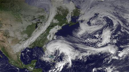
The final countdown to Hurricane Sandy’s arrival has begun, and this extraordinary and historic storm is already causing havoc all along the U.S. coast from North Carolina to Massachusetts. The scale of this massive storm truly earns Sandy the title of “superstorm”. Sandy’s tropical storm-force winds span an area of ocean 940 miles in diameter, and both North Carolina and the island of Bermuda, 700 miles to the east, are under tropical storm warnings. The region of ocean covered by 12-foot high seas spans an area of ocean an incredible 1560 miles in diameter. Winds near hurricane force are expected to affect waters from Virginia to Massachusetts today. Record storm surge flooding has already occurred in regions along the New Jersey coast this morning, and the highest water levels recorded in over a century of record keeping are expected over much of the New Jersey and New York coasts this evening during the 8 – 9 pm EDT high tide cycle. Sandy brought sustained winds of 60 mph and waves 30 feet high early this morning to the buoy east of Cape Hatteras, NC. A wind gust of 58 mph occurred at New York City’s La Guardia Airport at 9:51 am EDT, and a buoy at Robins Reef, NJ recorded sustained winds of 42 mph, gusting to 55 mph. As of 8 am EDT, Sandy has dumped heavy rains of 7.87″ at Cape Hatteras, NC; 4.01″ at Ocean City, MD; 3.12″ at Dover, DE; and 3.22″ at Virginia Beach, VA. As of 9 am EDT, peak storm surge values of 5″ were observed at Lewes, Delaware, 4.2′ at Cape May, NJ, 4′ at Atlantic City, NJ, 2.9′ at Philadelphia, and 3.9′ at New York City.
Latest data from the Hurricane Hunters shows that Sandy is intensifying as its core traverses the warm waters of the Gulf Stream. At 8 am EDT, an Air Force hurricane hunter aircraft found top winds of 98 mph in the heavy thunderstorms to the southwest of Sandy’s center, at a point about 150 miles east-northeast of Cape Hatteras, NC. A dropsonde released in the eye measured a central pressure of 945 mb, but observed winds of 19 knots at the surface, so Sandy is probably a 943 mb hurricane that is very close to Category 2 strength. The Hurricane Hunters did not observe an eyewall, and saw very little temperature difference from inside to outside the eye, so Sandy is not going to be able to undergo rapid intensification. The storm could still see an increase of 5 mph in its winds before landfall tonight between 6 pm – 10 pm EDT, due, in part, to interaction with the low pressure system to its west that is pulling the hurricane towards the coast. The new, higher winds of Sandy don’t have a lot of time to pile up additional storm surge water, so the NHC storm surge forecasts will probably not change today. But it is clear that Sandy is not going to pull its punch, and this superstorm is going to deliver a punishing multi-billion dollar blow to a huge area of the Eastern U.S.
Figure 1. Morning satellite image of Hurricane Sandy.
Sandy already producing a record storm surge
The National Weather Service in Atlantic City, NJ said that isolated record storm surge flooding already occurred along portions of the New Jersey coast with this morning’s 7:30 am EDT high tide cycle. As the tide goes out late this morning and this afternoon, water levels will fall, since the difference in water levels between low tide and high tide is about 5′. However, this evening, as the core of Sandy moves ashore, the storm will carry with it a gigantic bulge of water that will raise waters levels to the highest storm tides ever seen in over a century of record keeping, along much of the coastline of New Jersey and New York. The peak danger will be between 7 pm – 10 pm, when storm surge rides in on top of the high tide. The full moon is today, which means astronomical high tide will be about 5% higher than the average high tide for the month, adding another 2 – 3″ to water levels. This morning’s 9:30 am EDT H*Wind analysis from NOAA’s Hurricane Research Division put the destructive potential of Sandy’s winds at a modest 2.9 on a scale of 0 to 6. However, the destructive potential of the storm surge was record high: 5.8 on a scale of 0 to 6. This is a higher destructive potential than any hurricane observed since 1969, including Category 5 storms like Katrina, Rita, Wilma, Camille, and Andrew. The previous highest destructive potential for storm surge was 5.6 on a scale of 0 to 6, set during Hurricane Isabel of 2003. Sandy’s storm surge will be capable of overtopping the flood walls in Manhattan, which are only five feet above mean sea level. On August 28, 2011, Tropical Storm Irene brought a storm surge of 4.13′ and a storm tide of 9.5′ above MLLW to Battery Park on the south side of Manhattan. The waters poured over the flood walls into Lower Manhattan, but came 8 – 12″ shy of being able to flood the New York City subway system. According to the latest storm surge forecast for NYC from NHC, Sandy’s storm surge is expected to be 10 – 12′ above MLLW. Since a storm tide of 10.5′ is needed to flood the subway system, it appears likely that portions of the NYC subway system will flood. The record highest storm tide at The Battery was 10.5′, set on September 15, 1960, during Hurricane Donna.
Rehobeth Bay Delaware
Atlantic City before the storm arrives. That is the boardwalk floating in the water.
Avalon and I got drunk at Fred’s Tavern in Stone Harbor in the old days.
And we’ve eaten breakfast at Uncle Bill’s Pancake House
The Bay has already met the Ocean in Ocean City
Cape May NJ
Atlantic City
Ocean City Pier
Wildwood
sangell’s advice @ 10:40 bears repeating.
So, here at the Stucko household …… the generator is filled up, it has been started, sitting at the ready just outside the side door …. and ALL the cords are laid. When/if power goes out, the sump pump, fridge, electric stove, kitchen lamps, and ‘puter will be hooked up and running within 2 minutes.
Just to be clear, the ONLY reason I’m doing all this prepping is so that I can continue to log on and post on TBP. I am dedicated to gloom and porn.
Sandy passed by the mid-Atlantic states as predicted.
I’d heard mentioned she could cause the national elections to be postponed. This may put a crimp in the global elites holiday plans, since the outcome is predetermined, but delaying the announcements may affect some travel plans.
On one hand, if you put the planes on the tarmac before the election is called, and the civil unrest commences, it could be seen as more than just prudent planning.
On the other hand, since the global elite have declared war on the general population, what difference does it make anyway? Bring on the right gear, in your face, bitchez!
@Admin: I am really sorry about your condo but if this storm keeps up it is gonna be a goner, even if it is 1/2 mile from the shore.
Here’s some pix from Galveston after Ike roared over it in 2008.
[img [/img]
[img]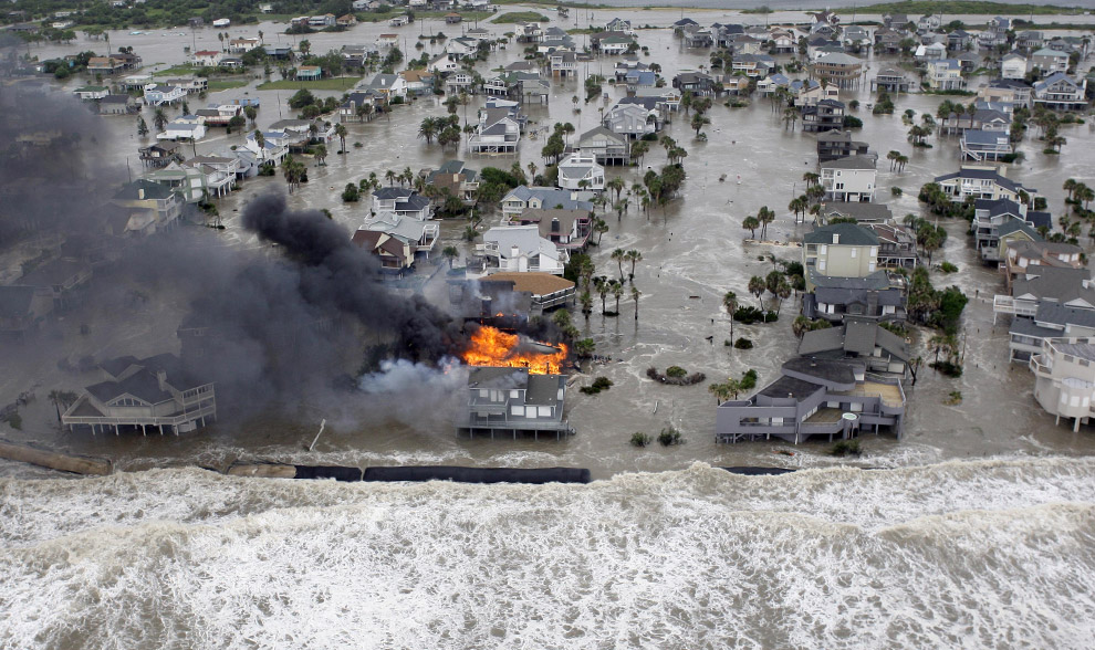 [/img]
Not trying to bum you out, just trying to get you used to what you are going to see when this storm comes over, sorry.
oops,
[img [/img]
admin, that path looks nasty, it looks like the storm is hitting you and my parents (phoenixville) and then heading directly over my house (just south of h-burg)
why is sandy being such a c#nt?
on a side note, I wonder how much krugman is creaming in his pants thinking about putting the “broken window” theory into practice on this scale.
Admin prepares his cat [/img]
[img
Admin prepares to feed the family [/img]
[img
Admin prepares for alternate sleeping arrangements ?w=510&h=302[/img]
[img
Sadly, Admin believes that he can continue to blog and post …. as long as he can still see his computer monitor [/img]
[img
Sadly, wordpress sucks donkey dick.
Power going off all over Long Island
http://www.lipower.org/stormcenter/outagemap.html
Admin, interesting pics you’re posting, but who on this life infested rock orbiting the sun is out there in a hurricane taking pics? As long as roads still exist, why aren’t they being used as the get -the -hell -away form Sandy route?
But ,still I’m glad their are saps willing to document what a real storm looks like
Stay safe ‘cuz it’s likely someone will need to be available to rescue Stuck.
@flash –
It was pretty easy to get people to stay out there snapping pictures. We just told the Section 8ers that the hurricane is part of a new MTV reality show.
Oh lookey here.
The little darlings are about to use Twitter to go on a post-Sandy looting spree.
http://www.infowars.com/gangs-plan-hurricane-looting-spree-via-twitter/
(yes I know it’s infowars)
3 guess as to ethnicity.
Asians?
Wildwood has already had 4.65 inches of rain.
It’s a full moon.
High tide is at 8:03 pm tonight.
Sandy will make landfall near Wildwood between 8:00 pm and 10:00 pm.
TPC, isn’t that how law enforcement now serves warrants.They advertize, free housing , hip hop or be a baby daddy with no strings attached reality TV auditions, or simply get a free gold plated teeth grill for just showing up,
and Voila’ warrants served .No driving around looking for perps .They show up in herds for their free shit share.
@flash
“TPC, isn’t that how law enforcement now serves warrants.They advertize, free housing , hip hop or be a baby daddy with no strings attached reality TV auditions, or simply get a free gold plated teeth grill for just showing up,
and Voila’ warrants served .No driving around looking for perps .They show up in herds for their free shit share.
”
Actual picture of FSA rushing to the new “reality TV show”.
[img [/img]
Oops, forgot to adjust for ethnicity.
[img [/img]
Admin, about three posts up the page, is that not the eye just off shore taking a sort of due west turn toward wildwood? Is it really going to take until 8-10 tonight for the eye to come ashore?
I_S
IS
They just updated the landfall to between 5 pm and 6 pm. It has increased its speed to 28 mph meaning the storm surge will be more powerful.
So it’s a bonus then?!!
I survived Hurricane Hugo in ’89 and vowed to never live in hurricane country again. I don’t recall ever doing any prepping so to speak. I had just bought two whole beef tenderloins and 40 lbs of king crab and had to grill that shit up (along with everything else in the freezer) before it went bad. For a couple of weeks, the residents of Horatio, SC worked their asses off all day long and ate like kings every evening! In a way it was sort of fun but I’ll pass on a repeat!
I_S
I wonder if your section 8 neighbors evacuated or decided to ride it out? If there is any justice in the world, theirs will be the only condo destroyed and you’ll never see them again.
I_S
Jeezus.
Making final preparations. Decided to top off gas in the car … about 1/4 tank. Went to the same gas station I went to earlier today to fill up three little 1.5 gallon containers. Sign out front — “out of gas”. Long story short … had to travel about three miles to find an open gas station. This isn’t Wyoming …. that means I passed about 20 closed gas stations. Maybe they just sent people home because it IS starting to get nasty.
Stopped by the A&P supermarket. Thought I’d get another gallon of milk and two dozen eggs. No problem. BUT … the bread shelf was completely empty … not even a single English muffin.
Drive home was interesting. Trees are starting to sway violently between gusts. I am really concerned about the four huge old trees in our yard. Was stuck at a traffic light. Between gusts the fucking light was swinging horizontal from one side to the other. I floored the little Honda once it turned green. lol
Keep posting Admin, great job. As I remember, your condo is on the second floor? No worries.
It’s kinda cool in S. Florida, 74 with wind. I’m on the cruise ship ready for departure. As near as I can tell, it’s geezers, boomers, and gays. Should be fun. Why are there so many fat boomers everywhere you go? They’re like locusts, only fat, with their stupid hippie long hair and ponytails. They look ridiculous. They never give up. I expect to be doing CPR on 3 or 4 when they keel over at sea, or explode from eating themselves to death.
I hope your generator works, so TBP stays up, and I can continue complaining about boomers.
Damn, Stuck, stay home. You don’t want to be decapitated by a sign, or crushed by a tree. Stay out of the fall-path of the trees, just in case.
These guys aren’t scared
[img [/img]
Guards at Tomb of the Unknowns to remain on-site during hurricane
the U.S. servicemen who guard the outdoor Tomb of the Unknowns at Arlington National Cemetery will remain on duty.
“They will not abandon their post,” an employee who answered the Arlington Cemetery’s phone confirmed to Yahoo News. He identified himself as “George,” but was not authorized to speak on the record to the media.
The tomb, located just outside Washington, D.C., holds the remains of unidentified soldiers from World War I, World War II, Korea and Vietnam.
The elite sentinels selected to guard it have kept watch continuously at the site since 1948.
No problemo AWD!!! Staying home for good at this point … probably won’t leave the house until Thursday …. unless my parents run into trouble …. “only” a 6 mile drive, fortunately …. and I’ll walk if I have to.
Never let a crisis go to waste.
[img [/img]
Regarding HZK’s post about looters @ 1:44. Some samle tweets ….
======================================================
“Bout to do some looting when this hurricane finally hits….gonna get a new laptop and tv…this hurricane might be the best thing to happen.”
“If this hurricane gets real bad I’m looting stores ! i always wanted to do that.”
“I’m gonna go looting once this hurricane hits Utica.”
“Has #HurricaneSandy made landfall yet? My bitch ass is ready to go looting!”
“helllll yeah I’m gonna go looting after the storm hits.”
“Who wants to go looting with me when Sandy hits?! I need some new shit!
======================================================
By the way, they are all ………………… blacks. Gasp!!!! Where the fuck is Colma?? I need his perspective and reasoned anlaysis.
[img [/img]
1) The storm will be incredibly bad bringing down the power grid across the entire US. 9 states will have flooding.
2) People will band together and hunt each other down
3) first responders will be too busy trying to help their families survive to show up for work.
4) under 10,000,000 people will die
5) Electricity will never be restored.
6) Amerika is done.
7) The government will cease to exist.
8) People will finally find out what freedom really means to their lives. Finally…
“Guards at Tomb of the Unknowns to remain on-site during hurricane the U.S. servicemen who guard the outdoor Tomb of the Unknowns at Arlington National Cemetery will remain on duty.”
Damn right they will! These men have a higher calling than themselves. They have integrity, honor, fortitude and a sacred duty they believe in.
I_S
AWD said:
” I’m on the cruise ship ready for departure.”
Damn AWD! I’m no germaphobe but I’d wager that your line of work is cleaner than the average cruise ship! They only way you’d get me on a cruise ship is if it rescued my ass from a raft on the high seas! Even then I might just ask that they throw me a line and tow me in!
Anyway, I hope you have a good time……..you need a break. How being surrounded by fat boomers qualifies as a break intrigues me.
I_S
AWD
We are heading out on a cruise in three weeks. I ignore the Boomers. A lounge chair, a pina colada, and a book is the ultimate vacation.
Shut down the power, shut down the subways, shutdown the freeways, shutdown the bakeries, shutdown the airplanes, shutdown the gas stations, shutdown everything… my have we become a pussy nation. We can no longer take care of ourselves. The government will save us.
I have been through some rough weather in my time along with many other people. Now that we have all this weather software and computer models we pick the worst ones to follow and prepare according to what the government creatures, politicians and media chicken littles tell us to do.
@Stucky –
Are those tweets just humorous fabrications, or are people really that stupid?
In between tears , Shep the Snot-sucker on Faux News is claiming that Sandy has the lowest pressure of any Northeastern storm ever recorded, which ain’t good newz.
Damn , where is RE when one needs a worst case scenario update?
Hurricane Sandy is strengthening and now has maximum sustained winds of 90mph. … winds of 90mph and a very low central minimum pressure of 943mb, possibly the lowest ever recorded on a hurricane this far north.
Her Stuchenmoobs:
Here I am!
Analysis:
They’ll see how much water there is and run the other way.
Looks like it may be a teensy bit bigger than the Australian tsunami. Beachgoelrs might get wet up to their ankles. If they are doing handstands that is.
If Llpoh was the mayor of Wildwood he’d berate anyone who decided to leave as pussies. He’d refuse to evacuate the retirement home, figuring it would be no great loss to get rid of a few more eaters. If someone called out because the roof blew off their house, he’d fire their lazy ass.
I’m pretty amused at all the HAARP weather-modification theories, especially given how the highest posting members view 9/11 and climate change.
Anyway:
1) We’ll know this WAS, in fact, HAARP, if Wall Street is spared while the rest of the east coast becomes Waterworld; and….
2) We’ll know it was an act of GOD (or space Jesus or the FSM, if you prefer) if Wall Street is obliterated while the rest of the country is largely spared.
Heaviest winds of the day. I actually felt the house move. Lights have flickered a few times, but we still have power. I’m north of the main thrust. Delaware and Southern NJ are getting the worst by far. The next 5 hours will be the worst of the storm. After 10:00 pm, it should start to improve.
Atlantic City. There are a lot of poor black people in AC. What happens next?
Admin
Just reading my portable generator manual. I have a Husky with a Briggs&Stratton engine.
It emphasizes that the first time it is used, that the oil must be changed after 5 hours.
just an fyi
The potentially worst Northeastern storm EVAH meets mostest important election EVAH!
Coincidence ?
I think not.
This storm has the GOP’s fingerprints all over it!
Stuck, Whaddya mean this isn’t Wyoming? We have 3 gas stations, after that, 30 miles north, 30 south, or 50 west to the nearest. Can’t drive East. Besides, we don’t need to evacuate. We’re already here.
Good luck back there, it was a bit nippy Saturday, high of 45 & I only caught 15 trout.
Chris Christie is giving a press conference and he essentially called the Democratic African American Mayor of Atlantic City Lorenzo Langford a fucking dumbass. This asshole mayor told people to not evacuate Atlantic City. The whole city is underwater and first responders cannot rescue anyone. When people drown to death, this idiot mayor will have their blood on his hands. Christie clearly thinks this guy is a worthless piece of shit.