

Via Ancient Origins
On a chilly winter day in 1929, Halil Edhem, the Director of Turkey’s National Museum, was hunched over his solitary task of classifying documents. He pulled towards him a map drawn on Roe deer skin. As Halil opened the chart to its full dimensions (two feet by three feet wide or 60 X 90 cm) he was surprised by how much of the New World was depicted on a map which dated from 1513.
The document was the legacy of a pirate turned Turkish Admiral, Piri Reis ( circa 1470-1554). He was born in Gallipoli, a naval base on the Marmara Sea and was the nephew of Kemal Reis, a pirate who had reinvented himself as a Turkish Admiral adventurer who had made his name in naval warfare. At the time, the distinction between pirate and Admiral was more flexible than might be expected from looking back through a Hollywood lens.
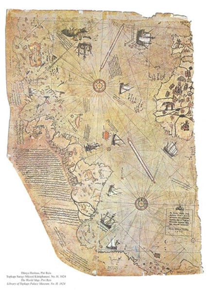
Map of the world by Ottoman admiral Piri Reis, drawn in 1513. ( Public Domain )
Piri Reis sailed with his famous uncle from 1487 to 1493. During these voyages, he was introduced to the lucrative spoils of piracy. The fleet fought pirates and captured and plundered enemy ships. In 1495, Kemal Reis’ great skill in the art of battle earned him an invitation to join the Imperial Turkish Fleet. His nephew accompanied him to his new assignment. The pirates were transformed into respectable Admirals.
After Kemal was killed during a naval battle in 1502 Piri Reis turned his back on the seafaring life and began a second career as a map maker. A perfectionist – Piri Reis would not tolerate the slightest error in his drawings – he created his famous map in 1513 using older source maps; including charts captured from Christopher Columbus. The Turks had boarded one of Columbus’s ships before the crew had a chance to throw the charts into the sea; standard practice in a time when the contours of the planet remained veiled in mystery and maps held secrets that were invaluable to pirates, admirals, kings and queens.
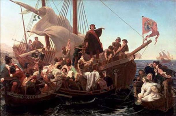
‘Christopher Columbus on Santa Maria in 1492’ (1855) by Emanuel Leutze. ( Public Domain )
A Columbus Controversy
The general public first learned of the existence of the Piri Reis map in the 27 February 1932 issue of the Illustrated London News . Entitled, “A Columbus Controversy: America – And Two Atlantic Charts”, the article noted that: “… Columbus got little further than the mouth of the Orinoco, in Venezuela, in his voyage along the coast of South America in 1498, so that the stretches of the South American coast given in the Piri Reis’s chart must have been copied from other sources.”
In the July 23rd edition of the magazine Akcura Yusuf, President of the Turkish Historical Research Society, wrote a more detailed account. The author pointed out a significant fact: “…the map in our possession is a fragment. If the Other fragments had not been lost, we should have had in our possession a Turkish chart drawn in 1513 representing the Old and New Worlds together.”
U.S. Navy’s Hydrographic Office.
An amateur scientist by the name of Captain Arlington Mallery made it his mission to determine the age of the source maps used by Piri Reis. So radical were Mallery’s conclusions that he hesitated to reveal them. In August 1956, he finally decided to reveal his findings on a radio show sponsored by Georgetown University. He explained that in June 1954 he was working in the map room of the Library of Congress when his friend “… the Chief Engineer of the Hydrographic Office handed me a copy of a map which had been sent to him by a Turkish naval officer. He suggested that I examine it in the light of the information we already had on the ancient maps. After making an analysis of it, I took it back to him and requested that the Officer check both the latitude and longitude and the projection. When they asked why, I said, ‘There is something in this map that no one is going to believe coming from me, and I don’t know whether they will believe it coming from you.’ That was the fact that Columbus had with him a map that showed accurately the Palmer Peninsula in the Antarctic continent.”
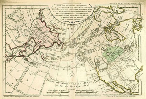
1753 world map by the French cartographer Philippe Buache. ( Public Domain )
Mr. Warren, the host of the radio show, interviewed Mallery and M.I. Walters of the U.S. Navy Hydrographic Office:
“HOST: You say that these maps have been checked by the Hydrographic Office of the U.S. Navy?
WALTERS: Yes.
HOST: As far as you are concerned, are they accurate?
WALTERS: Yes, they are.
HOST: How old are the maps?
WALTERS: These maps go back 5,000 years and even earlier. But they contain data that go back many thousands of years previous to that.”
Walters remarked on the comparisons between the Piri Reis Map and the newly (1954) discovered sub-glacial features of the Queen Maud region of Antarctica:
“We have taken the old charts and the new charts that the Hydrographic Office produces today and made comparisons of the soundings of salient peaks and mountains. We have found them to be in astounding agreement. In this way, we have checked the old work very closely. We put very much confidence in what Captain Mallery has disclosed.
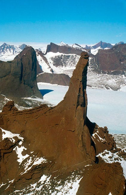
Charnockitic rock needle, northern Holtedahlfjella (Kurze Mountains), Queen Maud Land, aerial photograph in SSE direction. (Wilfried Bauer/ CC BY SA 3.0 )
HOST: Mr. Mallery, this must then lead to the conclusion that there were competent explorers and map makers along the coast of the Atlantic long before Columbus.
MALLERY: Several thousand years before. Not only explorers, but they must also have had a very competent and far-flung hydrographic organization, because you cannot map as large a continent as Antarctica as we know they did – probably 5,000 years ago. It can’t be done by any single individual or small group of explorers. It means an aggregation of skilled scientists who are familiar with astronomy as well as the methods required for topographic surveying.”
Hapgood and the US Air Force Cartographic Office
One of Charles Hapgood’s students told him about the radio broadcast. The Professor was immediately fascinated and decided to: “…investigate the map as thoroughly as I could… 4
Since Mallery had used the US Navy for his investigations Hapgood decided to get a second opinion from the Cartographic staff of the Strategic Air Command (SAC). The U.S. Air Force investigation came to the same conclusions as the US Navy. They determined that the southern part of the map did in fact depict portions of sub-glacial Antarctica.
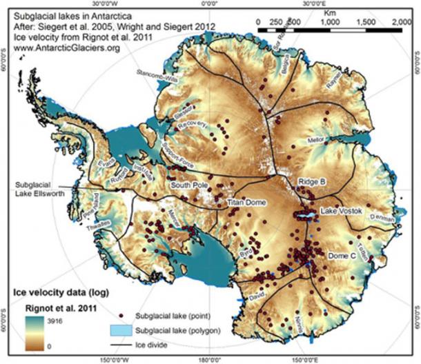
Subglacial lakes identified beneath the Antarctic continent. (AntarcticGlaciers.org/ CC BY NC SA 3.0 )
Conventional wisdom dictated that the island continent hadn’t been discovered until 1818.
USAF Lt. Colonel Harold Z. Ohlmeyer wrote to Hapgood on the 6th of July 1960.
“Dear Professor Hapgood,
Your request for evaluating certain unusual features of the Piri Reis World Map of 1513 by this organization has been reviewed.
The claim that the lower part of the map portrays the Princess Martha coast of Queen Maud Land, Antarctica, and the Palmer Peninsula is reasonable. We find this the most logical and in all probability the correct interpretation of the map.
The geographic detail shown in the lower part of the map agrees very remarkably with the results of the seismic profile made across the top of the ice cap by the Swedish-British-Norwegian Expedition of 1949.
This indicates the coast line had been mapped before it was covered by the ice cap.
The ice cap in this region is now about a mile thick. We have no idea how the data on this map can be reconciled with the supposed state of geographic knowledge in 1513.
(signed)
HAROLD Z. OHLMEYER
Lt. Colonel, USAF
Commander”
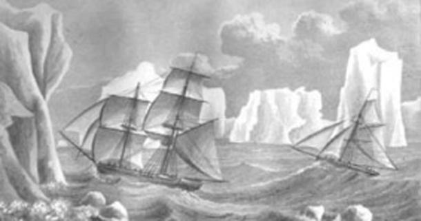
Painting of James Weddell’s second expedition to Antarctica in 1823, depicting the brig Jane and the cutter Beaufroy. ( Public Domain )
Corresponding with Hapgood
Our adventure with the study of ancient maps began in the summer of 1977 when Charles Hapgood replied to an article we wrote outlining our belief that Antarctica was once the site of Atlantis. We’d concluded that Hapgood’s theory of earth crust displacement was the missing link that could unravel the mystery of the lost island continent. Charles replied:

“August 3 rd, 1977
Dear Rose and Rand,
I am astonished and delighted by your article which arrived here today. Believe it or not, it is the first truly scientific exploration of my work that has ever been done. You have found evidence for crust displacement that I did not find.
However, it would seem that you are not aware of a book I published in 1966 entitled Maps of the Ancient Sea Kings. Since you are considering presenting your article to the Royal Geographical Society (of which I was a member until I stopped paying my dues), you should examine this book, and I am mailing a copy of it to you.


The real question is: Of all the information you know and all the information there is, which is greater??? … the next question will be more difficult to answer: What is the percentage of all the information there is do you actually know??? … So in actuality when making an opinion or statement the accurateness is the same percentage …. now for the life changing question … Why do the educators of our realm insist on teaching false information??? … ever hear of ‘The blind leading the blind’??? …. Solution: connect directly with ‘All that is’ (best definition of God known to man) … be on your way now, quit being lazy and connect ………….
You need to watch out for the “not invented here” crowd. When you come upon a collection of apathetic collaborators like that they tend to fight like all hell in a last ditch attempt to maintain their “self eating watermelon”. This is similar to the progressive world today as they stare down a recalcitrant Donald Trump as he dissects and disassembles their perfect world……..
Pop the popcorn and melt the butter…….
Probably made from old satellite maps.
People think the antediluvian world was primitive for some reason, but it wasn’t.
“People think the antediluvian world was primitive for some reason, but it wasn’t.”
I agree 100% In fact, I suspect that civilization was more advanced than our own in many ways and relied on a technology completely different from our own. That’s why some ancient technological discoveries may be totally missed by our current science – they just won’t understand what they’re looking for.
One thing I also found interesting. If you go to the USGS site that is mentioned in the article and look for the LandSAT map of Antarctica you will find that the hi-res image is available for the entire continent EXCEPT the area right around the south pole. Why no images of that area?? Here’s the link: https://lima.usgs.gov/access.php
About 40,000 years ago a team set out from present day Turkey to explore for the perfect place to build the domicile for the couple we now call Adam and Eve. In those days there existed large birds capable of transporting 1 or 2 individuals. Being very intelligent these birds were trained to provide aerial transportation for the then living human population. And while the above was revealed to us I speculate that maps of our world were long in use prior to those days.
Sadly those birds died out about 30,000 years ago.
Incidentally, the land chosen is today below the waters of the Mediterranean off the eastern coast.
The source for the above comes from The Urantia Book, which will be ridiculed by those unthinking individuals who’ve responded to previous post I’ve make referencing that book. But someday, whether it be in a hundred years or a thousand, that book will be regarded as the single most important book ever published.
Would fit in with the global flood stories and other lines of reasoning where the world rotational axis shifted (causing the floods) and moving the alignment of the world (and Antartica) so that Antartica became covered with ice.
Supposedly when Nixon visited China he was presented with an ancient map that accurately depicted the western U.S. including every peak in the Rockies.
For anyone interested in this kind of topic a good book is Dead Men’s Secrets by Jonathan Gray. Some of it is a little ‘out there’, but very intriguing.
A little newer and more accurate map of the world…[img [/img]
nkit, that’s funny. Unfortunately, it is absolutely true.
Thanks for the laugh.
nkit
Funniest “American observation” of the world is Southeast Asia – noodles. As a Vietnam vet, oh, how I wish that were true, but Thailand comes pretty close.
Fascinating article and links. Kudos for posting it.
I had read once upon a time that Bolboa had a copy of this map as well.
Further, NOAA used this map and superimposed the satellite imagery of the land mass over it and the map is identical. It is stunning.
I ponder in my reading how we know what we know and how much as a species did we know and have lost . Considering these bits and pieces of the ancient puzzle that is or was us ???? Keep floating to the surface !
It is intriguing food for thought .
[https://m.youtube.com/watch?v=-VUmtCLePL8&ebc=ANyPxKpECutpdKCGXzGjIYOLUEIrh4qqgLSh04E6u-fo71sbeC293Wsz9AEeXzdhDYGsrbEw-4-zF0hpvH2hvkG7yQcbg1nIcg]
Some extra material for contemplation along those lines.
PROOF the earth is flat!
[img [/img]
Insane in the membrane. If the earth was ‘flat’ “CATS” would have knocked everything over the edge.
Oh wait, that’s right, there’s a ”dome”. I forgot. Ya know, if it were flat, there would still be gravity and if you got too close to the edge, you’d fall down sideways. So, there’s that . .