

If you own real estate, do you know where your property line is? Do your neighbors agree with the boundary between you and them? Are you sure? Maybe this article can shed some light on any questions you might have about property line delineation.
From mid-2016 to early-2018, this author worked at the County Assessor’s Office as a G.I.S. Property Specialist for the largest county in Arizona. My duties required me to research title histories and make absolute determination of property boundaries and ownership. This research was used to prove exact property boundaries and property ownership. Some of the relevant records found in this research dated to the late 1800’s. Reading cursive hand-writing on microfiche copies of transfers of title for real property that sometimes mention consideration (payment) in the form of chickens and livestock was always an entertaining highlight to work that is very boring and clerical.
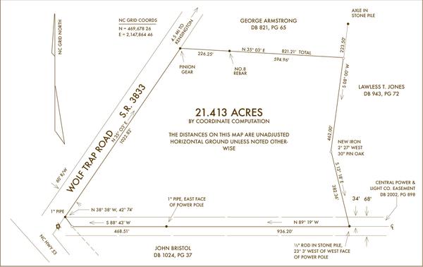
County Assessors are the government entity typically charged with the responsibility of recording real property ownership of private and public entities, and the boundaries between properties. This record is more than just a map, it is also a record of who owns which property. The Cadastre, (effectively a database) as this record is called, is a comprehensive legal register of real estate and real property ownership and is considered as the definitive arbiter of most all boundary disputes. Public rights-of-way are another major portion of real property that a County Cadastre delineates.
https://www.heavy.ai/technical-glossary/cadastral
Before I go any further … I am offering no paid services here, nor am I offering any legal advice.
If you are a property owner, I’d like to exhort you right now to take proactive measures with your title, and especially the property descriptions that define your property boundaries.

Know your property boundaries to the 1/4 inch, or better. I highly recommend finding the local surveyor in your county who has the most experience with property boundaries and especially in writing good descriptions that can be reproduced for decades to come. He can set iron stakes at your property corners that you will have certainty are where they are supposed to be. Just use a competent surveyor, for your own peace of mind. For the sake of legal arguments to be avoided in the future, do not rely on an app or anything other than a registered surveyor when determining your property lines.
What I mean is, most surveyors know not to use a tree or a rock for a Point of Beginning, as a crude example. A good cadastral surveyor will know how to “tie-in” his descriptions to already established adjacent properties and known control points. He will do the research needed to find the appropriate property descriptions for ALL the adjacent properties to yours.
He will also know how to write property descriptions that will be easy to recreate, possibly with a bit of redundancy (secondary measurements and or control points) included in the boundary description, just for good measure. (Sorry, THAT pun -was- intentional. I regret nothing.)
There are two types of systems used for describing real estate boundaries:
The first of these systems is known as PLSS – Public Land Survey System, a rectangular grid system, based on arbitrarly lines (baselines), and divided into Township and Range sub-grids, is used by the vast majority of states in the U.S. for real estate property boundary descriptions. This is the system that creates “sections” of land, i.e. 640 acres.
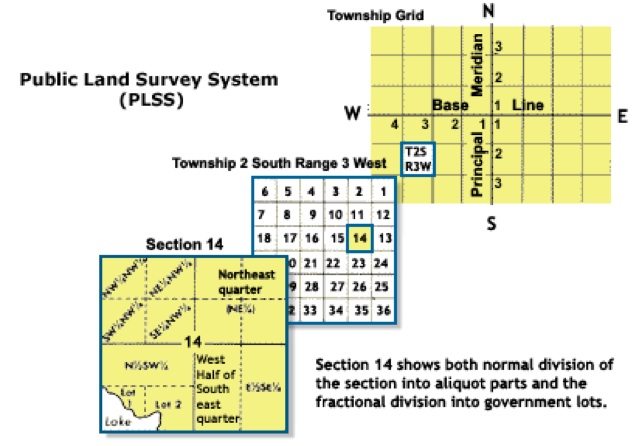
https://www.gislounge.com/what-is-the-public-land-survey-and-why-do-we-still-use-it/
The second system is known as Metes & Bounds – based on items in nature that are (mostly) permanent, like a river bend or an old oak tree… where ol’ whats-his-name was hanged in 19-aught-9.
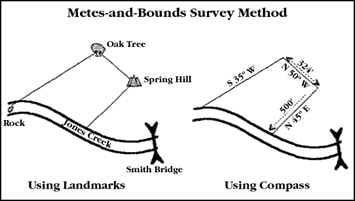
Metes and Bounds Definition
A metes and bounds description can be lengthy, confusing, and daunting to a novice who may not know how to read and interpret its narrative. The description defines the lands from the point of beginning (a property corner) around the entirety of the parcel, typically in a clockwise fashion, back to the point of beginning. Each line or course is described by two components, the “metes” and the “bounds.”
- The metes is the math of the described property lines that circumscribes the perimeter of the parcel.
- The bounds are cited to state what each line is bounded by.
Metes and Bounds Example
An example of a defined property line by metes and bounds would be “ {Ooze’s note: this description is missing a Point Of Beginning, therefore, rendering it invalid! Property boundary descriptions MUST be absolutely correct to be legal!} Thence North 89 degrees, 39 minutes, 47 seconds West, a distance of 147.33 feet (the metes), along the southerly line of property now or formerly owned by John Smith (the bounds).”
The math, or the metes, contains three parts to define the line:
- A directional call
- An angle described in degrees, minutes, and seconds
- A distance typically cited in feet and tenths of a foot
In the above example, the directional call is North/West. The angle is 89 degrees, 39 minutes, 47 seconds (also delineated as 89° 39’ 47”) and the distance is 147.33’ (or feet). When calculated, observed, and reconciled by the surveyor, the metes should form a mathematically closed figure.
All state statutes for the practice of land surveying include precision requirements with very stringent tolerances for closure.
Despite the potentially daunting exercise of translating arcane gibberish into a valid and useful map of a property boundary can actually be pretty simple. If you are lucky, your county assessor has created a “Parcel Viewer” that will enable you to extract important property information by using a color map with aerial imagery.
Maricopa County, Arizona, the home of Phoenix, has an excellent “parcel viewer” interface for their Maricopa County Assessor department. It really is one of the best in the nation. Just for reference, Maricopa County is roughly the same size as Harris County, Texas, home of Houston.
https://maps.mcassessor.maricopa.gov/
Are there potential pitfalls to taking an active interest in properly delineating your real estate property lines? That’s hard to say. Mostly, expect to find inconsistencies that have been propagated from one title agency to another as the property has been conveyed from one party to the next over the years. “Cut and Paste” is not your friend in this realm of real estate.
There are plenty of online references that provide definitions, concepts, examples and anecdotal accounts of the pitfalls of the various title types and transfer methods. Below is a link that looked good to me with just the few dozen seconds of perusal I had time to give it. There are some important concepts on the following website that would require too much time to elaborate upon in this article.
https://www.upcounsel.com/lectl-property-boundaries
There are so many intricacies to titles and property boundaries that I couldn’t hope to give those topics the time and energy they deserve. Suffice to say, property boundaries and titles for real estate and real property do not have to be so technical as to be impossible to understand.
If your county isn’t as digital-friendly as Maricopa County is, you may need to go old-school and head down to the County Courthouse, or whichever government entity hols such records, like a County Recorder.
https://www.waldeneffect.org/blog/How_to_do_a_property_title_search/
https://www.waldeneffect.org/blog/How_to_map_property_boundaries_from_a_deed/
Title Lock deserves your diligent research. I don’t have any expertise on “Title Lock” at all. My expertise is 1) determining clear title, and 2) accurately mapping property boundaries from published property descriptions. The mapping part is referred to as Cadastral Mapping.
https://www.heavy.ai/technical-glossary/cadastral
Property descriptions written by surveyors can be a huge source of trouble for future transfers or simple fence construction. Know your property boundaries at risk of losing your real property. It happens all the time. A neighbor builds a fence that isn’t on his real property. An easement is the usual compromise, since the fence is already built. Save yourself future potential aggravation by being proactive in delineating your real estate property boundaries. Don’t let your property be held in limbo by a bureaucrat in some future time who is “just doing his job” by holding up a title transfer due to irregularities. It’s YOUR property! It’s up to YOU to hold it.
I’ll do my best to answer any questions on this subject that I’m qualified to answer. Bear with me, though. I’m in the middle of a major relocation effort.


Reading cursive hand-writing on microfiche copies of transfers of title for real property that sometimes mention consideration (payment) in the form of chickens and livestock was always an entertaining highlight to work that is very boring and clerical.
And likely to make a comeback in short order.
Q: How do you utterly confuse Millenials & Zoomers?
A: Tell them to read cursive, ask them to drive a stck shift, and dial a rotary phone.
For extra credit, tell em to drive a stick shift while reading cursive and texting on a rotary phone.
And get em shitfaced first.
Please post results to YooozTubez!!!
…and put in an 8-track and maybe to get the time of the day on the CB.
8-track, might be kool to turn back the clocks to Grand Funk Railroad.
or get a job.
Surveying was a passion of mine for about 13 years. Reading metes and bounds descriptions of old surveys was always interesting. I met many people older than I with far more experience in boundary surveys and I’m not talking surveying 20 acre or less tracts. These folks traced old Spanish land grant surveys in Texas.
The thing with the Spanish land grants and older surveys is the calls for monuments marking a “corner” or angle point in a “property line” may have disappeared 100 years earlier. The old timer surveyors relied on things like stones piled at a “corner”, easily knocked over and spread about or plowed under , or a tree they called the corner or a tree or trees marked with an ax , normally an “X” on the side of tree facing the “corner” as a witness tree. Witness trees and any number of “calls” in a metes and bounds description were treasured when trying to establish an original land boundary. Trees die and are removed for whatever reason, perhaps uprooted by tornadoes or destroyed by fires. The “historical” aspects always intrigued me. I was basically a city slicker surveyor as bumper stickers designed for city slicker surveyors read “Keep On Building America”. I did some large acreage surveys in West Texas but nothing like tracing old Spanish land grants. “Follow in the footsteps of the original surveyor” was the necessity.
You must have come across a lot of Vara’s* in those old Spanish titles! Ah… to have title to property under a Spanish Land Grant. Are they still untouchable (un-taxable property)? Or is that a myth? Does the King Ranch hold property under a Spanish land grant?
*For the not-so-nerdy, a VARA was the Spanish unit of measuring length, especially in property boundary descriptions. 1 Vara = 33-1/3″ (thirty-three and one-third inches).
Certainly knew the old lingo and things like in below link:
https://americanhistory.si.edu/collections/search/object/nmah_1065091
A nice article 20 years old about King Ranch:
https://www.texasmonthly.com/news-politics/the-secret-history-2/
I was fortunate during the 80’s to have attended a seminar sponsored by what was known then as the Texas Surveyors Association held at Texas A&M University. There was a man at the seminar whose name escapes me that was 90 years old and one of few that could tell stories about establishing land boundaries from Spanish land grants to those issued by Stephen F. Austin.
I pulled this up if anyone is interested in searching information from the Texas general Land Office:
https://www.becomeatexassurveyor.com/history
Thanks for the article.
For folks who occupy land in Texas:
Your property is described in the deed records kept by your County Clerk’s office. Property descriptions are used to create GIS maps for property tax purposes.
Almost every County Appraisal District has interactive maps online, easy to find your property, or anybody else’s.
BTW, Central Appraisal Districts SUCK !!! Unaccountable bunch of bureaucratic twats, my County Chief Appraiser is an idiot, rose far above her level of incompetence, only good at increasing property valuations annually.
My Counties’ CAD website:
Also townships etc. aren’t a thing in Texas. Example: The NW 1/2 the SE 1/4 of Block 31 of the T&P RR survey, Abstract 108. Then the metes and bounds in varas.
http://www.caldwellcad.org/data/_uploaded/file/taxinfo/Texas%20Land%20Measurments%20Guide.pdf
We ain’t got no townships.
Screw you , we’re from Texas!
I recall the “Quilt Lady” in Comanche , Texas. 🙂
…maybe before “your time”.
BTW, Dan Patrick dang sure ain’t Texas to me. SMDH
Thanks for the concise comment.
We got you beat on slimy County Assessors, though.
https://www.fox10phoenix.com/news/paul-petersen-pleads-guilty-to-human-smuggling-in-adoption-scheme
That Texas Monthly article on the King Ranch was an excellent read. Thanks for the link.
In that article, the author relates how the King Ranch hired an artist who was good at painting realistic looking cattle. That reminded me of Ace Reid. Man, I wish his cartoon weren’t so hard to view!
http://cowpokes.com/?v=47e5dceea252
The old Cowboy Cultural Society internet radio was awesome with cowboy themed music and cowboy poetry. It’s innovator d.j. Laura Ellen Hopper, died in ’07.
https://www.kpig.com/laura-ellen.htm
Thinking about cowboy poetry checking this out:
https://archive.org/search.php?query=cowboy+poetry&sin=&page=2
https://www.westernfolklife.org/
The prperty next to me mums on Marthas Vineyard if you dug far enough back was bought for 6 barrels of dried cod!
Was a bit of a pain selling me mums property and guy who bought it agreed with me best case would hand him title on sheep skin for a certain amount of gold,we would have a few drinks and the deal would be done!
As mentioned,may be the past is again our future.
Do people really own anything today? I mean It seems like they are just care takers until someone takes it from you.
I only speak for myself, but you don’t really own the land, the land owns you.
One generation passes away, and another generation comes; But the earth abides forever.
Stop paying the tax on it and you’ll soon find out who the real owner is.
and it will be in a well armed group ready to throw all your junk to the curb.
To which comes the typical reply. meh

Yes. People own the title, deed & right to pretend they own property. And it’s enough. Fumes.
Property was crypto even before the counterfeiters dream-schemed to bring the con•cept to bear on currency. Schwab’s bumper sticker is already largely fait accompli. For now.
fee-simpletons, absolutely. (my term for “highest Deed land holding”. There is no private individual Allodial Title issued in the US.
The word “fee” is related to the term fief, meaning a feudal landholding.
Fief. A Shire Feif, became Shire-Reeve, in the days of England in 871, and was responsible for collecting taxes and enforcing the “Kings Orders”.
Thus: “Sheriff”
Not trying to be Sister Mary Elephant here, but next week we’ll cover “escheat”. Escheat originally applied to a number of situations where a legal interest in land was destroyed by operation of law, so that the ownership of the land reverted to the immediately superior feudal lord.
If all it takes to make the sale is sizzle, why throw in the actual steak, too? Ahh, breathe in ~ savor those steak fumes ~ the gathering gloom, watch lights fade from every room …
The notion that satellite (items of property) are disconnected separate “just things” is just another artifice compartmentalizing / rationalization in the divide/conquer metastasis. All those “disconnected external things” aren’t just yours. They are you.
It gets worse. The external objects are just external objects & are not yours & are not you … unless those objectified externalities are other people. Then its “I am he as you are me And we are all together See how they run Like pigs from a gun …” Or Piggy’s to a conch shell. Piggy shoulda’ ducked. But Piggy never ducks. At least not the incoming externalities that should be ducked – & then permanently ko’d.
Regrid.com is pretty good for finding property owners:
https://app.regrid.com/us/ny/kings#b=admin&base=satellite
Do you have any idea where Kyckuyt Farm is/was in Buswick (Brooklyn)? Hendrick Jansz and family lived there starting in 1660 and in 1680 moved across the river after changing family name to Brevoort in 1677. Home was at 21 Fifth Avenue and portions of the farm stayed in the family for over 200 years. The old Brevoort Hotel was later built on the property. Same for Grace Church at Broadway & 11th Street. Still looking for the damn deed so I can reclaim the 11 or so acres.
The retired surveyor who originally surveyed our place has promised to find our corners going on 9 months now. He was supposed to be here last week. We have irregular property lines and only one side has an intact fence which is obviously way inside my property line and there is some minor disagreement on the other side with one neighbor.
Here it is almost winter and I just got my auger, still don’t have fence posts cut and still no survey. If my body was as willing as my mind and heart, I probably still wouldn’t be done.
To be fair, this guy is going to be a fraction of the cost of a firm, if we can get him out here and since I am still clearing fence line, it’s not really an inconvenience that he still hasn’t shown. I am more worried about the ag lime arriving like it is supposed to. Small homestead farms are bottom of the list with fertilizing companies.
My biggest dilemma with the fence is going to be deciding what to do with some massive oaks that are in the way but would be a shame to chop down. Felling sweetgums is a different story, because that is more like revenge for seeding my pastures. There is not a more obnoxious tree than sweetgum except possibly Chinese privet which we also have in abundance. The sumac is easy to control by comparison to the other 2.
Most people don’t keep the corner posts marked. I had a line survey done for a fence and dropped a t post every 100 ft. Same with the corners.
In the way? As on a fence line?? Where a building is going to go?? Theres always work arounds. When we had our small farm we had over twenty walnut trees and the leaves are filling with tanines. I raked and burned them for the potash, fertilizer and weed killer.
Be a shame to lose all the leaves and nuts that would come off them, as well as the shade they give to people and live stock as well.
We have no shortage of trees, because there are lots of little copses in our pastures that were left untamed and we have a forest on 2 sides. I just want my fence on my property line. I already have to clean up 6 giants that fell over in a storm about 5 years ago that were left by the previous owners – no trivial task. I am not sure I want future problems on the fence line, but it would break my heart to chop down an 80 year old healthy oak. I think I will attempt to fence around the few that might be in the way.
Such an old tree deserves to be saved, if possible. Is there a family cemetery on your property? Just thinking out loud. Maybe you could establish a family (community) cemetery and have it held in a trust? Problem boundaries can sometimes be dealt with using a completely different approach like that.
Y’all inspired me to save the trees, but I will need to get a clearer picture before I decide how to accomplish it. I have several ideas now.
Our 20 back in KC area had an oak from the Civil War days; tornado in the 1960’s took out the top center section of what used to be a majestic, very old tree, but it still stands. It gets plenty of water from a spring coming out of an acre of old growth across the road that is now protected and is never to be disturbed.
What part of the world are you located? Sweetgums are native here and they sure too and have colorful fall foliage. Some people don’t like them because of the Sweetgum balls. I’ve one Sweetgum in my yard proper and I rake the spiny balls and burn them. The forests around me are a different story as the Sweetgum thrives here. Sweetgums are also harvested along with pine for destination to the paper mills. I like them actually. 🙂
Cedars out in prairie country are pretty obnoxious and highly despised by ranchers.
Eastern Red Cedar (Aromatic Cedar) here. It’s not difficult finding a source and a small saw mill operation to cut boards. Good stuff.
If you don’t order a survey and obtain title insurance before buying property, you’re just flat stoopid. Prior to becoming a county after the Revolutionary War (founded in 1711), we were the seat of one of the six judicial districts in SC. Our title was traced back to Book 1/Page 26.
Your whole property was or part of your property was once part of the property that was in Book 1/Page 26? Big difference.
In the future your real worry will be over your head as to what space is yours, not just on Terra Firma. Do you own the air space over your land? As things take to the sky, do TPTB have the right to use your airspace? Another reason for Mericans to maintain arms.
Javelins and LAWS rockets are quite plentiful on the Dark Web these days.
THANKS UNCLE SAM!!!
Yeah … but the shipping charges from Ukraine must be awfully expensive …
Plus shipping insurance is no longer available at any cost-unless you buy it from a guy named Hunter.
My understanding a land owner’s airspace is 500 feet. That means any aircraft one may consider threatening or the pervert operated drone that is too close can be shot down.
An incident I recall and of course forget the year involved a homeowner on a residential subdivision lot somewhere in Florida. Some perverted individual “flew” his drone around the neighborhood peeking in on residents “privacy” around their backyard swimming pools. The homeowner shot the drone down, I think a shotgun. Since local code prohibited discharge of firearms I believe the homeowner went through some time of grief over “legal charges”, believe it or not , not only discharging the firearm but damage vandalism/damage to someone’s “property”.
500 feet is about 166 yards. I feel confident I can bring down a sizable bird , like a duck , at 60 yards with #5 lead shot ( oops steel shot required) in a 2-3/4 ” 12 ga shot shell. For drones however , I might consider a big step up in pellet size to #4 buck ( a suitable whitetail load in brush). However #4 buck is not going to travel any further so #5 lead or even #4 lead with a bigger pattern will damage the plastic on a drone a pervert is likely to purchase. I’m talking those commercial box store type drones. Authorities no doubt use better quality drones since they have taxpayer $$$ to do so. Despite possibility of being penalized for protecting one’s long forgotten or respected “privacy”, I would cherish an opportunity to down some perverts drone. Flying around trying to peek in people’s windows…disgusting.
Get a grapple launcher or build one. String it with a weight and heavy fishing line. Shoot over the drone.
Tangle and crash. Reel in and sell the parts on eBay.
Or a .22 pellet gun. No noise and the pellet will not hurt anyone when it cones down.
Net-gun if they come close enough.
Dirty Old Joe likes peeping in windows, especially where there are little girls inside..
My property line ends where my tax liability begins. Tax assessors eat shit.
Tell me something I don’t know, flash! Scum rises to the top, if we let it!
If you can stomach it, have a look at this County Assessor for whom I was working from 2016 to 2017. I met him once and was soon out the door, on my own accord. He struck me as a slime-bucket when I shook his hand. Glad-handing and all smiles. By the way, Utah wasn’t the only state to indict him.
https://www.fox10phoenix.com/news/paul-petersen-pleads-guilty-to-human-smuggling-in-adoption-scheme
The French burn down the tax offices. I like their style.
The French once loved America, back when we were sorta free. They even bought us that statue. Wha’ happened?
BL, that was their old style. I liked it better than their new.
Please use your name, why does most everyone respond to me as a Anon? I don’t bite.
I never grasped why they built a city below sea level like New Orleans. They were a lot of crusty pirates I suppose like Jean Lafitte.
Dang!
I searched for this information when we bought our home. Built shortly after The War of Northern Agression it is on the farm of what I assume was a freed slave, last name Freeman. Underground RR was very active in the area.
Strangely, our home shows on a corner lot. Mr Freeman’s map shows a road next to it. The road either never existed or was forgotten because it isnt shown anywhere, including the county/township tax maps, except for the hand drawn plot that was executed on Mr Freeman’s death.
Searching title history if you have an older home. It connects you with the people who lived and died in your home while history was happening.
I had no idea of the number of old canals that cris-crossed Maricopa county in the past. So many of them no longer exist, with no trace of them every having been built.
It truly is a trip down into history when a title search takes you into a different era. I’ve found deeds that actually made me laugh out loud with the words selected by the author. There are also cases of blind hatred between parties being expressed in some conveyances. Either way, you’re right AB, searches like this can definitely connect you to a different time.
Yours is certainly an interesting livelihood. I’ve researched deeds and conveyances pertaining to family going back into 1890’s. One deed described a road as Bogus Springs Road. I asked local surveyors, city government and county type peeps, older folks…no recollection of Bogus Springs Road.
Researching further I discovered an area about 12 miles south of the legal description mentioning Bogus Springs Road that was indeed a spring! Oil was bigger here up until the late 80’s. I found accounts of oil companies in the area in the 40’s that mentioned Bogus Spring as it was well known and utilized by oil field workers ( and local residents) as a source of drinking water for it’s sweaty hot here summers.
Turns out while I find no recollection of Bogus Springs Road and it’s location since has platted with the establishment of a small town early 1900’s , the road named something else, there is a Bogus Springs Cemetery and somewhat older named community near the actual spring. So, the Bogus Springs Road apparently existed at least in what peeps of the times referred to it and likely peeps drove wagons 12 miles to gather what must have been some sweet spring water.
Nostalgic history rocks.
Another source of good laughs is visiting old, old cemeteries out West and reading the inscriptions on tombstones if they have not yet weathered away. My grandfather’s cemetery is up on a mesa and has lots of bawdry epitaphs from the rough and rowdy days.
Shafter cemetery and ghost town are a hoot.
http://www.cemeteries-of-tx.com/Wtx/Presidio/cemetery/oldshafter.htm
If your property is near downtown in larger (50,000+) city, Sanborn® Maps are helpful. These date from the 1860s and were used to calculate fire insurance rates. You also can order historic topographic maps through the USGS.
But, you can order both through Environmental Data Resources at edrnet.com. EDR owns the Sanborn library, so they’re the sole source.
My aunt was a nurse in a small Ohio town …
One night she made the acquaintance of a new patient on her ward, and what with a bit of conversation, the old woman patient realized that my aunt and uncle lived in the very property that had been in her family for more than 150 years.
The next night, my aunt brought in the whole box of stuff that came with the purchase of the 125-year old house … and showed the items to the old woman.
The box contained not only the deed when they originally acquired the property, but photographs of the original house and the property dating back 100+ years. The old woman asked my aunt if the creek still ran through the property — and my aunt said it did — and the old woman told of how the family had a small grain mill there on that creek. One time there was an accident — an explosion in the grain mill — that propelled one of the sons of the owners into the side of that house — head went through the siding and he died instantly.
History … family … all linked at times in an interesting tapestry … brought to light by coincidence and happenstance … like meeting an old woman in a hospital room late at night …
I own a pretty large parcel of property that was in a family for over 100 years. As a result it started out very large and over the years it was lotted a few times, mainly to friends or family. On one end I have a lady who lives in a small 1/3 acre parcel that came from my parcel. She has a small house and garage with a little lawn. Half her shed is on my property and behind the shed is a pile of junk accrued from her ex husband many years ago.
Down on the other end another chunk of 3 acres was lotted off. This parcel is really interesting and has caused me some headaches. Based on the survey maps, half of the driveway is on my property. This was most likely intentional because 50 years ago the driveway was a small road that went to the back of my property. The trail still exists and I use it. There is also a garage built that is properly within the property bounds, however a lean-too/wood shed was added off the back and that is entirely on my property. Oh and the well for the house on that parcel is….ding ding…on my property.
I have good relations with the two parties noted above. I am not going to harass some single old lady to move her shed and I have been slowly cleaning the junk pile. I have used the driveway that the other land owner has to haul wood out from the back section of my property. I also will not make him take the wood shed down. All of these issues were before their time and honestly trying to resolve them would most likely turn into more headaches. Plus there is that whole squatters rights nonsense where someone has used it long enough it essentially becomes theirs. I don’t agree with that of course.
Communication with the parties involved is what it really boils down to. The only concern I would voice would be for future conveyances of that property.
Your relationship with those other parcel owners can’t be conveyed in a legal document. It might behoove you to go ahead and address these encroachments with the parcel owners in an egalitarian fashion. Have a surveyor “carve out” parcels for the shed, road and water well an create an easement or a right-of-way conveyed to your subdivision or to another person, or keep them for yourself. You don’t have to come across as an ogre or something nasty just because you want to clarify boundaries and provide for the future.
There are options available to you that can be resolved with minimal expense and a better guarantee of fewer hassles when this property of yours needs to be conveyed to someone else.
I wouldn’t offer these suggestions normally. But, I had to deal with way too many cases of people taking your attitude toward clarifying long-blurred property lines. It really is easy to approach this topic with a positive, forward-looking attitude.
Regarding the squatter’s rights… the law trumps all else. I’ve had to create new property descriptions for people who squatted, sometimes unintentionally, for the requisite amount of time to allow for the property to be transferred without a single mention of consideration (payment). The original property owners were, invariably, just nice guys who didn’t want to make waves. Obviously, it’s your call. I only worked at that job for 2 years, but I was top of my class, so to speak. I don’t want to see anyone burned because they are a nice person.
I would like to have some right-of-way down that driveway. Right now it is a simple – “Hey I am going to be hauling some logs out Saturday, if thats okay” and it generally results in a “sure, go ahead” response. I think he does it because he knows the driveway is on my property and doesn’t want to poke the turd as they say. If he did deny me, honestly I wouldn’t even bother to try using the driveway. I happen to own all around the guy with the exception of the road frontage. I could always make my own road on the other side of the driveway and it would look like shit from his front porch. I think he knows that.
You deal much with undivided properties as a result of someone dying intestate? Talk about a pain in the ass when Hatfield – McCoy type families carry the chip on shoulder for 40 plus years.
It’s pretty easy to research your state laws concerning rights of adverse possession. We have mountain property in what was developed beginning in 1929 as a summer community (that of course now has several year round residents). Lots of uncertainties about property lines/lots of encroachments. Gets to be a real pain in the ass when the county interferes with a property sale and they demand this and that-can be expensive to placate the bastards with their demands. Their favorite these days is demanding road easements from all contiguous property owners, even if they are not a party to the sale.
If there is a government tax on your property, you don’t own it. Who cares where the property lines are…the line in the sand is the more important one.
Yes they do. Otherwise the parasitic legal system would be out of a job.
Why can’t I upvote you 1000X!
If it weren’t for my past experience in the land surveying business I probably would have no interest. While a different subject, I detest anyone advocating eminent domain for private gain.
A lot of politicians violently agree with your opinion.
If you own real estate
I reject this premise. The government owns all of the land and you are just a tenant. Don’t believe me, just fail to pay your property taxes and see how long you can stay on that particular piece of real estate.
My land backs up to an national forest, so the way I see it, I get millions of acres for nothing and even if I did have property rights to it I wouldn’t change a thing. Sometimes Gods landscaping and architecture simply can not be improved.
Truly a blessing, Boogieman. I grew up on the edge of a massive Loblolly Pine forest that extended down from the Sam Houston National Forest north of Houston, through The Woodlands and finally down to the creek behind our subdivision. We had free access to thousands and thousands of acres with no fence lines. The youth of today have nothing even remotely close to that sort of wilderness. I even heard a kid at the grocery store checkout line state that “nature sounds scare” him. I couldn’t believe what I heard. One of my closest friends once told me, “Ooze, your couch is the entire outdoors.” He wasn’t wrong. I’m genuinely happy to hear of your place next to a national forest. If I were a tree hugger… heh…
We have lived in this alpine forest for many years. My 3 boys now men grew up here and the forest was their play ground. We never take for granted the blessing of being able to live in this place and we give thanks for it. We hope to continue to live here for the remaining portion of our lives. When the SHTF we are no where near the flat lands. I know my neighbors and I know this forest. A country boy can survive.
“Some say he’s still up there today…”

I meant to add some context to this great still photo, from an even greater movie (if that even makes sense.)
This photograph is from the movie JEREMIAH JOHNSON (1972) and is, in my opinion, Robert Redford’s best movie.
https://www.imdb.com/title/tt0068762/fullcredits?ref_=tt_ov_st_sm
Our mountain property is close to a National Forest that has periodic forest fires that get larger and larger every time. The Forest Service “manages” and sadly is hell bent on limiting public access-their favorite excuse: “because we don’t have the funds”.
Up in Idaho, people are fond of seizing their neighbors’ land through a process called “adverse possession”. If someone has put a fence across the property line onto your land, used your land regularly as an informal easement, farmed your land, or used land you own in any way, and you don’t stop them, they can legally take the land from you or declare an easement permanent. Yet, due to the high cost, people often refuse to pay for surveys and delineate their property lines. We had our four contiguous parcels (totaling 130 acres) surveyed, and it’s one of the best investments we ever made (for many reasons).
Adverse possession…. that says it all, doesn’t it?
We’ve lived in NY, PA, VA, CA, SD, and now Idaho. We’d never heard of “adverse possession” until Idaho. Maybe it exists in other states as well. I just don’t know why someone would want to do that to their neighbor, but it’s common.
Expressly prohibited in the Bible.
So is being a prick to thine neighbor!!!
I’ve lived in ten states, been through a lot more. I don’t know why “neighbor” has the cachet it does. But it sure has gotten inside a lot of heads. Dr. Jekyll & Mr. Hyde is not a “strange case” at all.
Sort of like the old squatters rights nonsense.
Ain’t if funny how the biggest scandal in history is just being memory holed ? Tax Dollars were sent to Ukraine, Ukraine invested it into Crypto, Crypto company converts it to cash and gives OUR tax dollars right back to Politicians. Money Laundering our tax dollars they had to borrow in the first place.
Your RENTAL.
As long as there is property tax, not yours.
That’s what 2010 Texas gubernatorial candidate Debra Medina use to say. Texas peeps don’t get it I guess.
Debra Medina is an awesome woman!
https://www.houstoniamag.com/news-and-city-life/2016/05/debra-medina-texas-republican-candidate-june-2016
Our Real Property professor in law school described to us an old English practice known as ‘beating the bounds’ … as a means of ‘documenting’ the property in question.
He described it as bringing a youth to the property in question (often as it was changing hands) and taken to all of the corners and/or turning points — and, at those locations, would be beaten with a switch so that he would remember where those locations were later. If, at some future date, there was an issue as to the metes and bounds of that property, that youth (assuming he was still living there) would be brought to testify as to his experience regarding that property … by walking that property and showing the parties where the points were that his beating had taken place years earlier.
Interestingly, wikipedia offers a totally different discussion … so I’m not sure what to make of what our professor told us …
How coincidental that such an article would be posted and we’re literally in the process of purchasing six acres adjacent to our three acres. I can’t obtain a survey within months of our closing this month.
Who would ordinarily compose the description of the plat that will be on the deed? I’m assuming the closing attorney. I emailed him asking just that question, haven’t heard back. We live in a very rural Appalachian county. Twice I’ve broached the topic of costs (Fees, taxes ect), upon visiting his office. He’ll respond with a verbal description of the costs. He’s a pretty elderly gentlemen and that seems to be the common way of discussing such things. I tried to be a polite as possible (But I was irritated with the seeming lackadaisical approach to this property transaction). We’re kind of excited about adding the acreage which will preclude any development on our Western side. At the top of the ridge is an at least 180 degree view of the mountains defining the North Carolina-Tennessee border.
I’m excited for you, falconflight! It sounds like a beautiful spread you’re creating.
The only advice I can offer is as follows: Do as thorough a property records research as you can for _all_ properties that surround those parcels you are acquiring, as well as those for the new-to-you parcels. The property descriptions within these deeds can be “recycled,” so to speak.
Having boundary descriptions for all adjacent properties allows for a much easier “transfer”or copy-paste of the relevant shared boundaries. This is exactly what the land surveyor should or would do before stepping foot on your property – collect all the relevant information for all adjacent properties, and use as much of the recorded descriptions from already recorded (therefore already vetted and accepted) boundary calls. (A boundary “call” is merely the verbal descriptions that describe the boundary lines, which any future surveyor could then recreate with no problems.)
It’s definitely a lot of work, but the hard work done at the outset will pay off in the long term.
As far as composing or creating new boundary calls for your acquired parcels of land, a registered land surveyor is likely the only person who can legally create a new description for the new parcel configuration. Some people like to merge the acquisition of multiple parcels into one large parcel. Others may keep the original parcels separate. Or, they may decide to further subdivide the parcel. Either way, you should check with your county recorder or public records clerk for better advice than what I can offer here.
Most land surveyors are competent, and honest.
Abe Lincoln, George Washington, and Thomas Jefferson all worked as land surveyors before their political careers.
And there are already pins set in most cases, if there is a plat filed on the land. It does take an experienced surveyor with the right equipment to find them. Surveyors locate the points on the ground that represent the legal descriptions in plats and land deeds. If there is any kind of problem with your land boundries after a surveyor finds the corners you will need to talk to a lawyer. Surveyors only set the points and find the points.
Trees have always been used for “tie ins”, to help in locating corners before the invent of metal detectors. They are very helpful to surveyors, sometimes only being located with probes after the trees are gone.
Witness posts! I have seen too many witness posts completely removed by private entities. First-order monuments have been yanked out of the ground by farmers because they didn’t appreciate the hard work and the added value to such a monument. They are called monuments for a reason, no?
In Bastrop, Texas, while performing a survey for TXDOT of all county roads in Texas, we had to dig through an asphalt parking lot to recover a high-order control point. The car dealership didn’t think anything of having that location paved over, but they kept the witness post!
Thanks for adding context to my spurious statement in the original article. If a surveyor is registered, he’s competent. Sometimes an article has to stir-up a bit of shit to get an audience to participate.
I was never a registered land surveyor, but I did work with many old-timers who were making the transition to GPS survey with dual-frequency, 12-channel Trimble units. I even became a registered Trimble Trainer for their primary survey unit. Back in the early days of GPS, when Selective Availability (i.e. intentional government blurring of positions for civilian GPS units) and PDOP (percent dilution of precision) dictated when we ate lunch. That is to say, there were periods of time in the early days of GPS satellite constellation configurations, with just a few birds in place by 1995, when the quality of GPS signals dropped below the threshold required for accurate survey. We ended up establishing our own GPS base station for post-processing corrections to be applied post-survey. Our base station was providing better correction values than The State of Texas Department of Transportation could provide us with.
I’ve had to dig holes in the center lines of a few roads to get to paved-over monuments, just using a hammer & chisel and a rock hammer. Set some cotton-picker spindles in road centerlines too. Kind of dangerous when only working with a 2-man crew.
A lot of the older monuments on the Texas/Arkansas border had whiskey bottles placed directly under the markers, in case the marker was pulled.
It’s a noble trade to work in, but summer in the south is way too hot to enjoy the work, especially when having to cut a lot of brush (hence the title: Brush Monkey). So I retired from that early and did some GIS & drafting work.
Bill Clinton (**spit**) is the guy who had the SA removed, around 1999/2000. I was in school at the time and PDOP was a determining factor for us too, also HDOP. Things got a little better when they added the Russian GLONASS satellites to the system. I think the U.S. only had about 24 GPS satellites at the time, if I remember right.
We used Trimble GPS units & total stations, along with Topcon and various other stations. ESRI GIS software (early versions). The Trimble units were dependable.
I enjoyed the outdoor work in the cooler seasons – you get to see a lot of interesting things and meet a lot of really weird people (usually unarmed, but not always).
Your article caught my eye, it is very informative and well written, and not something you run across everyday on the internet. Good information.
Thank you
I was advised by a land surveyor to always bury a handful of copper pennies under the iron border pin, so that if your neighbor pulls up the pin and moves it over 6 feet gaining that amount for his property, you could still find the original pin location using a metal detector. Another good investment is to have an environmental phase 1 report done on any large tracts of property before the sale, it’s a small investment that could save tons of money and aggravation. You may find that your land, way back in the 1930’s was used to train soldiers for military service and the land (and water) is polluted with lead from used ordnance and rocket residue requiring massive brownfield remediation, or you may learn that the land you bought for a subdivision is on top of a forgotten mercury mine..
Reading the older CC&R’s from appraisal reports from the 1950’s is entertaining as well as regards who can occupy the property (no Mexicans, Negroes or Swine to be kept overnight)…