

Submitted by Hardscrabble farmer
If you haven’t been paying attention there has been a movement afoot to “redraw” the map of the world in order to accord the proper size of landmasses to each continent/country. According to those behind this push, the traditional maps of the Earth are racist as they were drawn by Europeans. Europeans being inherently racist, intentionally misled the world by making Europe- as well as other European controlled land masses- appear larger than continents with darker colored populations. Therefore, everything you know about how the planet looks is not only racist, but incorrect.
You would think that NASA could easily solve this problem by showing us the photographic evidence of the continents of Earth in their proper locations and scale, but of course NASA and all of their optics are also inherently racist so they must also be perpetuating a fraud upon the darker colored people of the world.
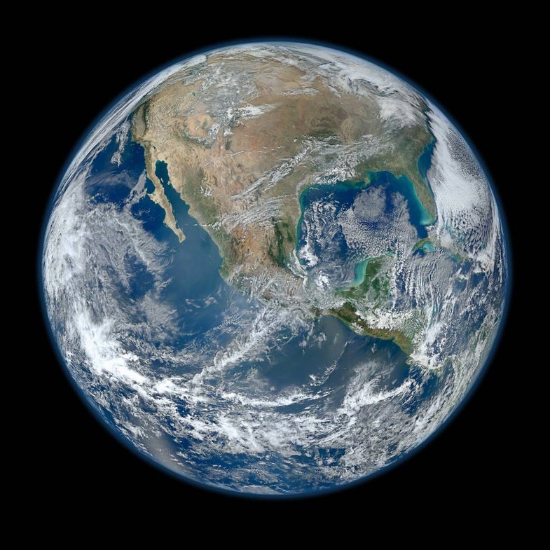
Photo of Earth and the United States of America (systemically racist nation) taken by NASA from space (allegedly).
Compare the scale of the US in the map in the article to the clear photographs taken from space by NASA and there appears to be a huge discrepancy, enough to confuse most people with even modest powers of visual perception.
So here’s the question. What do you believe? The creators of drawn maps or the photographs taken by NASA from space? The anti-racists that challenge the orthodoxy or those who question everything? What is the size and shape of the land masses covering the planet and why does it seem so difficult after all this time to map a relatively small planet, accurately?
Are maps and photographs inherently racist in order to make Africans feel oppressed? Are the things we have been told about the shape and size of Earth true or are they false and how could we possibly know, being not only inherently racist, but by not having access to those great cameras and space craft NASA has that can reach space and also alter the scale of the landmasses they photograph in order to maintain systemic racism against people who look at maps and photos from space.
As the author of the article states-
“In a more globally connected world, geographic literacy is more important than ever. As people become more accustomed to equal area maps and seeing the Earth in its spherical form, misconceptions about the size of continents may become a thing of the past.”
Unless, of course, we’re talking about genuine photographs taken by NASA from space which seem to intentionally distort the size of these landmasses in order to perpetuate global illiteracy about Earth in its spherical form.
Discuss.
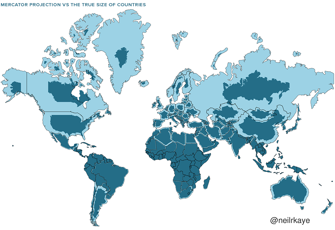
Mercator Misconceptions: Clever Map Shows The True Size Of Countries
Maps are hugely important tools in our everyday life, whether it’s guiding our journeys from point A to B, or shaping our big picture perceptions about geopolitics and the environment.
For many people though, as Visual Capitalist’s Nick Routley shows below, the Earth as they know it is heavily informed by the Mercator projection – a tool used for nautical navigation that eventually became the world’s most widely recognized map.
Mercator’s Rise to the Top
With any map projection style, the big challenge lies in depicting a spherical object as a 2D graphic. There are various trade-offs with any map style, and those trade-offs can vary depending on how the map is meant to be used.
In 1569, the great cartographer, Gerardus Mercator, created a revolutionary new map based on a cylindrical projection. The new map was well-suited to nautical navigation since every line on the sphere is a constant course, or loxodrome.
Geographic Inflation
The vast majority of us aren’t using paper maps to chart our course across the ocean anymore, so critics of the Mercator projection argue that the continued use of this style of map gives users a warped sense of the true size of countries—particularly in the case of the African continent.
Mercator’s map inadvertently also pumps up the sizes of Europe and North America. Visually speaking, Canada and Russia appear to take up approximately 25% of the Earth’s surface, when in reality they occupy a mere 5%.
As the animated GIF below—created by Reddit user, neilrkaye – demonstrates, northern nations such as Canada and Russia have been artificially “pumped up” in the minds of many people around the world.

Greenland, which appears as a massive icy landmass in Mercator projection, shrinks way down. The continent of Africa takes a much more prominent position in this new, correctly-scaled map.
This visualization also highlights how distorted neighboring countries can look in Mercator projection. In the GIF above, Scandinavian countries no longer loom imposingly over their European neighbors, and Canada deflates to a size similar to the United States.
Despite inaccurate visual features—or perhaps because of them—the Mercator projection has achieved widespread adoption around the world. This includes in the classroom, where young minds are first learning about geography and forming opinions on the relationships between countries.
Getting Reacquainted with Globes
Google, whose map app is used by approximately 150 million people per month, took the bold step of using different projections for different purposes in 2018.
The Earth is depicted as a globe at further zoom levels, sidestepping map projection issues completely and displaying the world as it actually is: round. The result is a more accurate depiction of countries and landmasses.
At closer zoom levels, users are typically using maps for things like navigation, which the Mercator projection was designed for. The exact angles of roads and borders are preserved in this projection.
In the Right Direction
In a more globally connected world, geographic literacy is more important than ever. As people become more accustomed to equal area maps and seeing the Earth in its spherical form, misconceptions about the size of continents may become a thing of the past.
It is my sincere desire to provide readers of this site with the best unbiased information available, and a forum where it can be discussed openly, as our Founders intended. But it is not easy nor inexpensive to do so, especially when those who wish to prevent us from making the truth known, attack us without mercy on all fronts on a daily basis. So each time you visit the site, I would ask that you consider the value that you receive and have received from The Burning Platform and the community of which you are a vital part. I can't do it all alone, and I need your help and support to keep it alive. Please consider contributing an amount commensurate to the value that you receive from this site and community, or even by becoming a sustaining supporter through periodic contributions. [Burning Platform LLC - PO Box 1520 Kulpsville, PA 19443] or Paypal
-----------------------------------------------------
To donate via Stripe, click here.
-----------------------------------------------------
Use promo code ILMF2, and save up to 66% on all MyPillow purchases. (The Burning Platform benefits when you use this promo code.)


LMAO, NASA…
Shit, these Africa earrings just got a lot bigger…

Tastefully understated.
She was KANGZ!
Somebody was not paying attention in 8th grade geography . To somehow proclaim a Mercator projection as some racist plot is moronic leftist lunacy .
Of course this is the type of group stupidity latched onto by the BLM and the 1619 band of fools .
Proper English RACIST !
Proper math skills RACIST !
Not cheering for a black teenage girl in Baltimore who proudly announces to the world “They said I couldn’t do it but I did it”
So proud of her high school diploma and her final 1.6 GPA !
A school system awarding a diploma for that is about as RACIST as you can get !
The achievement gap is not from a stretched projection or a skewed photo thru a camera from orbit in space around the earth .
Accepting lowered expectations and cheering when they show up in another black youth prepared for absolutely nothing would be laughable if it were not factually pathetic !
Now come all the leftist excuse makers scurrying about as they attempt to cover up their own shit and failures while pointing blame at everyone but themselves !
First maths was rassis, now geography.
Blacks are capable or more, but do we have the right to force them? They don’t do it on their own. That should be abundantly clear. On every continent.
How exactly does Russia shrink that much and still border China, etc properly? Just sounds like more revisionist bullshit. I’m fine acknowledging that flat maps do a poor job of properly showing curved area, especially when longitude and latitude must be correct…..but this just seems like more anti-white racism.
If that was accurate, it would take half a day to cross the United States northern border into Canada
Not without a vaccine you don’t.
Speaking of misconceptions…
https://mobile.twitter.com/RaheemKassam/status/1425960519090020357
“Speaking of misconceptions…” I thought you were talking about Hunter Biden for a second there.
The Mass Delusion is bigger than you think.
Another shiny thing meant to distract and divide. Not fooled Mercator. Not fooled.
Simply use a globe for proper size and distance perspectives. Not that Auntie has been or flown everywhere but the representation provided by a sphere seems relatively accurate.
Flat or Hollow Earthers are still on their own.
The Hollow-Earthers ruled the roost back in the day, in Estero Florida. The local sheriff beat the crap out of their leader Mr. Teed, and the entire movement went into…. er… eclipse.
I like globes a lot. Only problem is the names and every now and again the shapes (borders) change. The one from when I was little has a lot of names like Tanganyika and Zanzibar my kids never heard of. French Indochina, Burma, Siam, the various Guyanas.
WTF…..
The biggest problem here is that the Mercator map shows the US as much larger than it is, encouraging all of the low intellect immigrant wannabes to think there is more room here than there truly is.
As Africa is map centric, its size changes little and accurately shows a very large land mass.
This is where people need to immigrate.
About the anti-racist clowns pushing this:
Have these people taken their shots?
Are they cleared for their booster?
You’re racist for posting this. 🙂
From a selfish standpoint, did my property get smaller? Am I going to have to move my fences?
Will my property taxes go down?
No!
reminds me of my home which borders government owned land in my back yard which everyone on our street has annexed a part of complete with fences and sheds. Not a single casualty in the occupation either
America is only a pygmy is a moral sense.
We will remain a Global Force for Good.
At least for another six weeks, minimum.
Dementia Joe has driven us right into a cement wall. The emperor has no clothes, no credibility and no support. We are well and truly fuqued as of right now.
AS usual nobody talks about Antarctica .
No talk until they figure out what lie to tell about possible signs of previous civilizations emerging from beneath ice melted by volcanoes. Currently the AGW whores say it was from before Antarctica moved to where it is today. LOL!
Ever since this came out nobody wants to talk about it.
https://www.hplovecraft.com/writings/texts/fiction/mm.aspx
“At The Mountains Of Madness” H. P. Lovecraft
The NASA photo looks Racistly Spherical too. Left all the other continents off the flat earth.
I read a comment from someone who was an literally an inch from Canada, since his map says an inch equals 5 miles.
I am glad other people want to worry about this shitte so I don’t have to.
That shrinkage reminded me of…(gulp)me, when I jump into a pool of cold water.
One of my best jokes when I first started comedy went like this-
I have a shower curtain with a map of the world on it. Which is pretty cool, because according to the scale my dick is a thousand miles long.
While on the subject.
Bring on the truth. We are all for it. The very large Saharan subcontinent is indeed very large. It is also much stupider than is realized, which is concerning as we have a huge part of the world, growing in population, with an average IQ of 70. Half of their residents are intellectually disadvantaged (or whatever the acceptable term for mentally retarded is these days). Most of the other half is barely educable. Shall we continue to grow this part of the world and send their inhabitants to Europe where we can dumb down that land mass to cure racism? That seems like an idea that would have been developed by the sub-Saharans themselves or a master-management ((clan)) that want to reinvent the planet to their liking. Bring on the truth.
Not to worry, Counselor. China, unencumbered by Western guilt, empathy and Christianity, has plans for the fertile vastness and mineral wealth of Africa. And it doesn’t include a few billion semi retarded Bantus.
The Chinese need Leibenstrom and they know where to get it.