The Time the USAAF Bombed an American City

Via Sierra Hotel

During the dead of winter, March 21st 1944; Miles City, Montana; local residents woke to their quaint little town being overrun and submerged by the rising frozen waters of the Yellowstone river. Ice jams were building quickly, raising the sub zero river water levels over 16 feet. As the blocks of ice, slush and freezing waters flooded into the city, residents were forced to flee their homes for safer grounds.

Continue reading “The Time the USAAF Bombed an American City”

A Modern-Day Paul Revere Not Warning of Noah’s Flood at a Wedding

By Doug “Uncola” Lynn via TheBurningPlatform.com


They did eat, they drank, they married wives, they were given in marriage, until the day that Noah entered into the ark, and the flood came, and destroyed them all.

– Luke 17:27


Over the last three months I’ve attended three weddings.  Whatever getting married in a barn signifies or portends, it’s trending, because that was the case for two out of my last three invitations.  Although one of the earlier ceremonies was held in an actual barn, the wedding and reception facilities where I attended this last Saturday appeared to have been specifically remade for human mammals because the venue was beyond elegant.

Being the very first betrothal I can recall ever attending in the month of December, it was no surprise the weather was bad given this time of year.  Fortunately, however, all of the important people were there.  Again, it wasn’t the storm that mattered that evening, but rather, more importantly, who showed-up for the feast. The accommodations were first class, and with all of the beautiful people in attendance, I commented to another guest it was like being in a movie or, at the very least, at a television awards ceremony.

The next morning one of my offspring texted me the following:


Was impressed last night by all the people who came up to you just to chat or for your advice and your handling of what could have been an awkward situation

Continue reading “A Modern-Day Paul Revere Not Warning of Noah’s Flood at a Wedding”

SEVERAL OCEANS UNDERNEATH THE EARTH’S CRUST

A fascinating new discovery. 

Especially interesting to Christians is how this relates to the Great Flood of Noah’s day.  The fact of the matter is the utter impossibility of covering the entire earth, even 40 cubits above the highest mountain, with water from the sky above.  Can’t be done … even with the so-called (and, unproven) canopy of “water vapor” that supposedly surrounded the earth in Noah’s time.

However, the Bible says that the flood started like this; — “the same day were all the FOUNTAINS OF THE GREAT DEEP broken up, and the windows of heaven were opened.”

If the “fountains of the great deep” refers to this massive underground ocean …. how did the author of Genesis know about that??

==============================================

Scientists discover an ocean 400 miles beneath our feet that could fill our oceans three times over

Earth is like an onion: Layers

After decades of theorizing and searching, scientists are reporting that they’ve finally found a massive reservoir of water in the Earth’s mantle — a reservoir so vast that could fill the Earth’s oceans three times over. This discovery suggests that Earth’s surface water actually came from within, as part of a “whole-Earth water cycle,” rather than the prevailing theory of icy comets striking Earth billions of years ago. As always, the more we understand about how the Earth formed, and how its multitude of interior layers continue to function, the more accurately we can predict the future. Weather, sea levels, climate change — these are all closely linked to the tectonic activity that endlessly churns away beneath our feet.

Continue reading “SEVERAL OCEANS UNDERNEATH THE EARTH’S CRUST”

WHERE WILL THE NYC RATS GO?

I bet you thought I meant the rats on Wall Street and in the JP Morgan building. Nope. I mean the real rats that live in the NYC subway system. Bloomberg has no problem with rats living under NYC, but has a huge problem with 32 ounce sodas and young people protesting. He is the chief rat and we will now see how incompetent he really is as NYC flounders for weeks because they were unprepared for a storm. But they sure can do a great job luring 18 year old Muslims into fake terrorist plots. Maybe he should have spent the taxpayers’ money on storm preparation rather than his nanny state initiatives and fake terrorist PR campaign. What a fucked up city and fucked up mayor.

Try watching the video without laughing.

Now The Rats Are Sinking The Leaking Ship

 
Tyler Durden's picture

Submitted by Tyler Durden on 10/30/2012 11:00 -0400

While the massive population of New York City is awfully impacted by Sandy, there is a more populous and even more caustic population that is struggling with the aftermath: Rats! As Forbes notes, the NYC Subway is notorious for its rat population and with all five subway tubes now submerged, one can only imagine where these cute cuddly rabies-wielding devil rodents will make their new homes. “Rats are incredibly good swimmers and they can climb” is hardly the reassuring news lower Manhattan homeowners were looking for, and as the Daily Mail notes, this could bring infectious diseases such as leptospirosis, hantavirus, typhus, salmonella, and even the plague into human contact. On the bright side (well not really), rats don’t need to bite a human to transmit its gross payload; rodent feces and urine can spread conditions like hantavirus just as easily – get long hand sanitizer stocks!

  • Rats can climb brick walls, trees, and telephone poles, and walk across telephone lines.
  • Rats can fall from a height of 50 feet without getting hurt.
  • Rats can jump three feet in the air from a flat surface and leap more than four feet horizontally.
  • Rats can scamper through openings as small as a quarter. General rule: If a rat’s head fits into the hole then the body will follow.


FRANKENSTORM BEARS DOWN ON ADMIN’S CONDO

It looks like my underwater Wildwood condo could be really underwater in the next few days. This storm is projected to make a direct hit on Wildwood. The last time a storm of this magnitude hit Wildwood was in 1962, exactly 50 years ago. It looks like we are going to have a helluva 50 year anniversary party. This storm is bigger than the 1962 storm. It is going to hit during a full moon. It is predicted to last for 36 hours. Wildwood is an island. When it rains heavily, the streets flood because the storm drains leading to the ocean cannot drain fast enough. In 1962 West Wildwood was virtually wiped off the map, as the back bay met the ocean. Here are a few pictures of the devastation:

Explaining The Shore Impact From Sandy


Sandy doesn’t have that same ‘tropical’ look that it had yesterday.  Don’t be fooled by the look though.  An approaching cool front and mid atmospheric trough will infuse additional energy into the storm over the coming days, with the result being a strong storm that will impact much of the East Coast.

Another post around midday from Kevin Wagner will outline the wind, rain, water impacts for the region.  Track does matter to a point but since the system will be evolving away from a purely tropical storm into a nontropical entity there are some things that this storm will have that will not be in your “usual” tropical system.  The wind field will be larger geographically — and not necessarily stronger to the north of the storm either.  Some wind gusts in the southwest quadrant of the storm may be stronger due to baroclinic influence. Whether the storm comes ashore in New Jersey or Maryland does not matter in the grand scheme of things for someone in Pottstown or Philadelphia — it will be windy for inland regions.

At the Shore, track does matter more.  Modeling does suggest a window from the Delmava to Long Island, with the very, very consistent European computer model continuing to suggest that Sandy’s low pressure center comes ashore over the Delmarva.

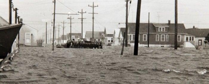
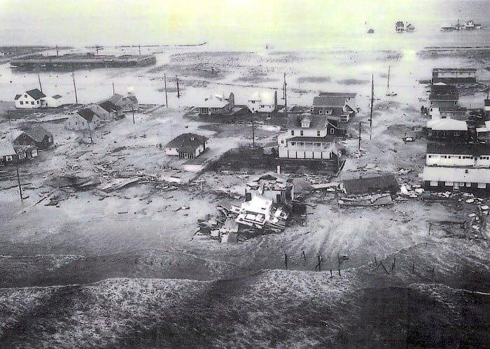
In terms of coastal impacts, the Euro landfall is arguably the worst case scenario for Delaware and South Jersey coastlines.  The combination of east winds and monthly high tides that will occur on Monday will cause rather nasty coastal flooding for Jersey and Delaware coastlines and the interior side of the back bays. Given the size of the storm, impacts will still be noticeable up the coast into New York City and Long Island as winds will be from the east, gusty, and pushing water onshore.  Coastal flooding impacts will be widespread over a larger swath of real estate.  East winds that could gust to hurricane force will do a number of the beaches and on Shore properties if the Euro’s scenario plays out.

If a landfall farther up the coast takes place…and this is an unlikely scenario, the impacts are different.  If the center comes ashore over Long Island (as an example), the strongest winds and onshore flow will be over the Hamptons and Southern New England while an offshore wind is pushing water out into the Atlantic over New Jersey and Delaware.  There would be some flooding from the back bays along the barrier islands in New Jersey once the storm center moved east of your location.  However, in terms of coastal flooding and beach erosion the impacts would not be as bad in this scenario since the storm would move onshore to our north.  Still bad since we would have to go through Sunday night and Monday with an east wind…just not as bad since the storm would track a little bit farther out to sea.  Odds don’t favor this scenario (at least as far as a Long Island landfall) playing out though.   However, it’s important to point out that with Sandy, despite its large size, the location where the storm comes ashore will matter for coastal residents in terms of how long the east winds last and how much coastal flooding takes place.

One of the differences between this storm and Irene is that Irene was faster moving whereas Sandy will be moving at nearly half of Irene’s forward momentum (ten miles per hour or so versus Irene which moved at nearly twenty) as it comes ashore. Irene’s worst impacts were in a six to eight hour window on Saturday evening until the dryslot moved in — Sandy’s brunt will be felt across the region for a longer stretch of time.